| home |
Risk
The Areas
Where in Viet Nam
DW works with the population of central provinces of Viet Nam, and since 1999
has worked in particular in Thua Thien Hué province, as well as smaller
workshops in neighbouring provinces.
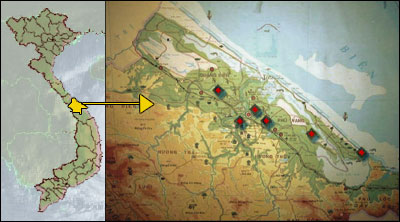
Thua Thien Hué (TTH) province is located in Central Vietnam. It borders Quang Tri province in the north, and Da Nang and Quang Nam provinces to the south.
Thua Thien Hué province has a quite narrow coastal plain with large lagoons, backed by mountains. Rain is frequent much of the year, and winters are wet and often quite cold, making living and working conditions harder.
Coastal lagoons stretch over 70 kilometres, and coastal districts house over a quarter of the province’s 1 million population. Much of the province’s economic activity relates to the lagoon and the sea, and people live in zones that are at high risk from typhoon damage and have little opportunity to move to lower risk areas.
The typhoon season stretches from June to December, and storms and flooding are frequent
*1.See, for example, the Central Provinces Initiative for
Natural Disaster Mitigation in Central Viet Nam, Second National Strategy
and Action Plan for Disaster Mitigation and Management in Viet Nam, March
2002.
*2 A recent Prime Ministerial Decree (August 2002) offers flood exposed families
to be relocated in a safer place in the Mekong Delta, with a credit system
for land (10 millions VN Dongs) and for a house (8 millions VN Dongs).
*3 Central
Committee on Flood and Typhoon Control “Official report on the damage
and response to flood and typhoons in the south-central and central highland
provinces of Viet Nam.” Hanoi, November 1999.
*4 Viet Nam News Agency, Nov 12 2001.