Wednesday, March 17, 2010
Documents Project DWF in Viet Nam (DIPECHO)

HANOI, 9 March 2010 (IRIN) - Serious efforts are under way to respond to the impact of climate change in Vietnam but a lack of capacity and resources remains a challenge, experts say.
Vietnam has been identified as one of 12 countries at highest risk from climate change and is the most threatened by rising sea levels, according to World Bank studies.
UN-cited data on global climate change and model studies show that Vietnam is at increased risk of floods and droughts, saline intrusion and increased health risks from heat waves, dengue fever and malaria.
However, experts say the government has acted quickly and is leading neighbouring countries such as Cambodia and Laos in trying to create policies to respond to climate change.
The National Target Programme (NTP) was approved by Prime Minister Nguyen Tan Dung in December 2008, and began implementation last year.
“Vietnam is to be commended for having pulled this off so quickly,” Koos Neefjes, policy adviser on climate change at the UN Development Programme (UNDP) in Vietnam, told IRIN.
Coordinated by the Ministry of Natural Resources and Environment (MONRE), the NTP is intended to help develop an overall climate change strategy, including goals for adaptation and the mitigation of greenhouse gas emissions.
The document lays out responsibilities for ministries and government agencies and asks all cities and provinces to devise their own climate change action plans by the end of this year, to be implemented by 2015.
It also aims to assess climate change impacts and ensure assessments are incorporated into development and investment plans.
Challenges
Vietnam is home to two major fertile plains, the Mekong Delta and Red River Delta, key agricultural areas and home to 40 percent of the country’s 86.2 million inhabitants.
They were identified as the most vulnerable areas in a November 2009 government report supported by the UN Environment Programme, which stated that more than one-third of the Mekong Delta could be submerged if sea levels rose by 1m.
Nine of the 10 provinces in Vietnam likely to be worst hit are in the Mekong Delta, but the effects on Ho Chi Minh City could be equally devastating.
Besides hosting potential climate change “refugees” from the Mekong Delta, infrastructure and housing would be damaged in the city, energy demands would increase, as would vector-borne diseases, experts say.
Vietnam is well-versed in water management because of a history of disasters such as floods, but there are questions over its capacity to fully implement policies, they say.
“The policy frameworks are very good. [The problem is] the capacity in government agencies to pick up on policy commitments. It’s not only skills,” said Jeremy Carew-Reid, director of the Australia and Vietnam based-International Centre for Environmental Management (ICEM) consultancy. There are possible hurdles in multi-tiered government with 58 provincial administrations.
“The challenge is to do the planning of the sectors [such as agriculture] as well as the planning in provinces,” said Nguyen Van Kien, climate change adviser to the UK Department for International Development (DFID) in Vietnam.
Strong coordination between sectors and effective oversight are needed at a national level, while capacity, technical expertise and awareness of climate change varies from ministry to ministry, according to a UN discussion paper on Vietnam and climate change released in December 2009.
“Provinces and lower-level authorities must rapidly develop their action plans to respond to climate change too, which will also require large-scale awareness raising and capacity-building efforts,” it says.
Funding questions
The government said last month it needed US$3-$5 billion until 2015 to respond to climate change.
“To protect Vietnam’s deltas and coastal regions from … sea level rise and related saline water intrusion, large investments in research and design are needed, followed by investments on an unprecedented scale,” said the UN discussion paper.
For the NTP, the government is aiming for foreign and private sector capital to comprise 60 percent of the funds needed for the activities outlined.
However, experts say it will be difficult to attract private sector funding for adaptation or mitigation measures. Meanwhile, Vietnam also needs to develop the capacity to access international financing available for climate change adaptation.
“Vietnam still needs to raise the money itself,” said UNDP’s Neefjes. “The high economic growth the country is experiencing is the magic bullet. Vietnam realizes it will have to rely on itself. If you can keep the economic growth up, the money will flow in the right direction.”
VietNamNet Bridge –Hanoi city administration has asked investors in 11 golf course projects not to continue, but rather pursue other plans.Eight other golf courses are allowed to continue.
The city requested that the investors contact the Hanoi Department of Planning and Investment to be provided with instructions on changing their plans, otherwise their projects will be denied permission to continue.
The 11 projects must be altered because they use large areas of rice fields in populated areas or they are not suitable for the city’s plans. If they go ahead, many farmers will lose land and become unemployed.
The eight golf course projects that are permitted to continue are located in Van Tri commune in Dong Anh district, Minh Tri commune in Soc Son district, Dong Mo commune in Son Tay district, Van Son commune in Chuong My district, Soc Temple in Soc Son district, Quan Son Lake in My Duc District and one in Long Bien district.
VietNamNet Bridge – Some land areas in South Sai Gon as well as canals and tributaries in the outskirts of HCM City have been improperly filled, causing flooding in many areas in the city, according to the Institute of Environmental Management and Science and Technology.
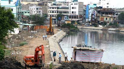
Construction workers toil on a project to build a stone embankment for Tau Hu stream in HCM City. Improper urban planning causes flooding in many areas of the city.
In HCM City, the high demand for land to build infrastructure and new urban areas has led to the filling of these waterways, with 2,600ha already filled over the years to build the South Sai Gon urban zone in the Phu My Hung area.
In addition, more than 6,300ha of land have been used to build industrial parks and more than 10,000ha of agricultural land for new houses.
As a result, upstream river water is causing widespread floods in the inner city, according to the Institute of Environment Management and Science and Technology.
According to local authorities, from 1990 to 2009, many businesses and individuals have filled hundreds of hectares of waterways to develop real estate projects without proper planning.
Cau Son and Van Thanh waterways in Binh Thanh District, Ba Mien in Go Vap District and Nhieu Loc – Thi Nghe have been narrowed, slowing down stream flow and drainage.
Many experts also claim that increased flooding is due to global warming, which has raised temperatures and sea levels.
However, recent research shows that the sea level of Vung Tau from 1990 to 2007 has remained relatively stable, while the water level of Sai Gon River at Phu An area has risen nearly two times, or 1.45 centimetres per year, and in Nha Be District, 1.17 cm per year.
City authorities say that the number of flooding incidents as well as volume of floods and flood-prone areas have increased dramatically in recent years.
In 1980, 10 spots in the city periodically flooded, while today that number has increased to 200.
As for flood intensity, before 1999 the highest tide at Phu An station was reported at 1.36 metres and occurred twice a year.
But now, the highest tide is reported at between 1.42 m and 1.5 m.
In 2008 and 2009, the highest tide in the last 50 years, which lasted for six consecutive days, was reported at between 1.54 m and 1.56 m, causing flooding of more than 100 streets with water level from 20 to 55 cm, or even 80 cm on some streets.
Floods have affected 154 out of 322 wards or communes, leaving 11,000ha of land fallow, affecting millions of people.
At National Highway 13, the Thanh Da residential area, street D2, Van Thanh area, and An Phu, An Khanh and Hiep Binh Chanh villa areas, as well as Districts 4 and 8, thousands of houses are about one metre lower than the street level, leaving them vulnerable to flooding and pollution.
If no effective measures are taken, the volume of flooding will increase, according to Le Huy Ba, head of the institute.
The city authority has asked localities to make detailed analysis of the proper use of urban land.
Lands planned for new residential areas and public works must be strictly under supervision, it has said.
In addition, authorities should recover the natural streams, ponds and lakes within and outside the city in order to reduce the number of floods, the institute said.
PORT-AU-PRINCE, Haiti (March 5, 2010) — Classes have begun again for the children of Cejecodema School in Martissant, an area on the outskirts of Port-Au-Prince in Haiti, thanks to assistance from Save the Children. The humanitarian agency has provided classroom tents and supplies so that hundreds of children in this quake-affected area could reinitiate their studies and regain a sense of normalcy.
In Martissant, where homes and buildings were destroyed by the January 12 earthquake, the large tents ensure that children can continue their education and play and interact with each other in a safe environment. Since the temporary school opened two days ago, attendance has increased by a dozen students, from 120 students to 132 students, and, the school director estimates the number of students could climb to up to 400.
Save the Children is focusing on offering children safe, temporary classrooms across the earthquake impact area as a key measure in helping vulnerable children recover from the disaster. The agency plans to set up about 300 temporary classrooms over the coming weeks, which would include repairing some less damaged school structures.
The Ministry of Education estimates that 90 percent of schools in the affected areas have been damaged or destroyed; that over 400,000 children have been displaced; and that only 50 percent of students returned to the schools that were undamaged and which reopened 1 February.
“Children have been profoundly affected by the events they have witnessed and experienced. Hundreds of thousands of children have been displaced, which is likely to have increased their sense of anxiety and fear, especially as aftershocks continue and buildings, including schools, continue to collapse,” said Annie Foster, Save the Children’s emergency team leader in Haiti.
Foster added, “These temporary classrooms provide children with urgently needed structured activities in a safe and protective environment, to help them return to normalcy, rebuild their resilience and have hope for a better future.”
In Martissant, 10-year-old Jimmy was in class for the first time since the earthquake.
“I like to study, and I want to learn,” said Jimmy. “My school fell in the quake but I don’t want to go back to it because I am afraid to have concrete over my head. I like this space because it is outside. I feel safe here.”
In a country where only 51 percent of children attended school before the earthquake and where, on average, children only completed four years of schooling, the impact of this disaster on education is a huge challenge. To ensure that children continue to have access to schools, Save the Children will work with both government schools and with private and community schools.
“Education is too important to be put on hold, especially in the aftermath of a disaster of the magnitude of the Haiti earthquake,” said Foster. “Education is not just a right; it can help protect children from disease or death by teaching them about hygiene and health concerns that have emerged as a result of the emergency. Education supports children’s psychosocial well-being, offering structure and a place to interact with others in positive and developmental ways.”
Save the Children has been assisting children and families in Haiti for more than three decades. In the hours and weeks following the quake, Save the Children distributed relief items, such as cooking utensils, soap, plastic sheeting, clean water, medicine and medical supplies, reaching more than 500,000 people with lifesaving relief. The agency has more than 500 staff in Haiti responding to the crisis.
Over two phases — the initial relief period of six months and then a recovery period of between six and 24 months — Save the Children expects to achieve five results in education through the following activities:
* 160,000 children access schooling in safe and protective learning
* Increased capacity of teachers to provide relevant, supportive, quality education for children
* Young children access quality early childhood development services
* 10,000 out-of-school children access quality, accelerated learning opportunities
* Strengthened partnership and built capacity of the Ministry of Education to provide quality education for children directly and indirectly affected by the earthquake
* Tens of thousands in Haiti still lack shelter
* Approaching rainy season threatens more misery
* Haitians find local solutions to lack of housing
PORT-AU-PRINCE, March 5 (Reuters) - Nearly two months after Haiti’s earthquake a shocking number of people lack shelter because aid groups are slow to deliver tents and tarpaulins, the international medical relief organization Medecins Sans Frontieres said on Friday.
The result is a loss of human dignity and the potential for misery and disease will increase when the rainy season arrives in April, said Colette Gadenne, emergency coordinator in Haiti for MSF.
“I was in camps where people have had absolutely nothing. They didn’t receive tarpaulins and tents and they weren’t even on the list (for deliveries),” Gadenne told Reuters.
“It’s shocking and extremely sad,” she said, adding that MSF, also known as Doctors Without Borders, would start distributing shelters to help speed the process.
Haiti’s earthquake struck on Jan. 12 and killed as many as 300,000 people, according to the government, leaving large parts of the capital and other cities in ruins.
Since then, life for many people in Port-au-Prince has stabilized as systems for water and food distribution improve and commerce, business and government have restarted.
Camps are also becoming better established and many families live in tents or have replaced bedsheets used for roofing with waterproof blue tarpaulins strung between poles.
The United Nations aims to distribute shelters to all the 1.2 million people displaced from their homes by April, according to Kristen Knutson, spokeswoman for the U.N.‘s Office for the Coordination of Humanitarian Affairs.
So far, 41 percent of that displaced population has received a tent of tarpaulin, she said.
“We are continuing to push things out the door as fast as possible,” Knutson said.
WHAT NEXT?
In the interim, tens of thousands of families are exposed to the weather. When it rained overnight on Wednesday many families got up to seek shelter and stood for hours, witnesses said.
At the same time, life in temporary camps is becoming less attractive as the immediate crisis and fear of aftershocks diminishes.
“Life is becoming very difficult in this camp. When the rainy season comes we will have lots of problems,” said Roselyne Lesil, 41, who was staying in a makeshift shelter in the Fort National neighborhood with two children.
The problem has pushed individuals and communities to seek their own housing solutions in the absence of guidance from the government or help from aid groups.
In Fort National, one of the worst hit by the quake, homeowners have set up a committee to explore their options and plan to secure the area’s perimeter and possibly start rehabilitation, said Ronald Lafalaise, 30.
Clearing rubble itself seems a herculean task in a neighborhood where the earthquake reduced a whole hillside of dwellings to debris and upended houses like toys.
At night many neighborhood residents stay in the Champs de Mars camp near the presidential palace for security, returning to check on their homes and do commerce during the day.
“People from the neighborhood really want to stay here (long term),” said Jean Sony Doralus, who was hacking at a shattered building with a sledgehammer near where his own house lay in ruins.
One priority for the government and United Nations is to move people from the most vulnerable camps and they advocate five possible solutions.
People should return to their homes if they are not too damaged, or set up shelters in the ruins of their houses, or move out of the city to live with relatives. Some 600,000 people have already done that, U.N. officials say.
Two other options, considered less desirable, are to improve the quality of the camps, thus making them more permanent, or to move camp dwellers to new sites.
Plans are laid for five new camps outside the city, but officials gave no details on where those sites were or how quickly people would be moved and the solution anyway might not be acceptable to displaced residents.
At the same time, the government says it wants to avoid anarchic development by residents seeking solutions for themselves.
“Certain people continue to build outside the established norms and it is the role of the government to be vigilant against this,” Justice Minister Paul Denis told Reuters, though it was unclear if the government could enforce its policy.
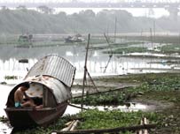
CIWIDEY, 3 March 2010 (IRIN) - Small-scale disasters affect thousands of Indonesians every year, yet the floods and landslides that constantly hit the country are overshadowed by more devastating events, agencies say.
One such disaster was a landslide in Bandung district in West Java province on 23 February, which buried more than 40 people and displaced about 1,000.
Three hectares of the Dewata tea plantation in Tenjolaya village, Ciwidey, gave way, creating a mudslide around 10m deep. The search and rescue operation ended on 1 March with 33 people killed and 11 still buried under the mud, according to the National Disaster Management Agency (BNPB).
More than 400 displaced people are now living in camps near the site in makeshift tents that they say are boiling during the day and cold at night. They are receiving rice, noodles and biscuits from the government and Red Crescent Indonesia.
�We need more help,� said Ajat, who has been living in a 3 sqm tent with his wife and two children since the disaster. �I don�t want my family to stay in this tent for too long, but we�re too scared to go back.�
Disaster-prone
Indonesia is the most disaster-prone country in the world, according to the UN Office for the Coordination of Humanitarian Affairs (OCHA); in 2009 alone, it experienced 469 earthquakes with a magnitude of five or higher � more than any other nation.
Some disasters are natural, while others are the result of poor urban planning, a lacklustre enforcement of construction and pollution laws, and environmental degradation.
The most common result is flooding, which has accounted for about 40 percent of Indonesia�s disasters in the past few years, according to government data.
Impact of floods in Indonesia
2005 2006 2007 2008 2009
Numbers killed 63 95 137 126 159
Numbers affected 23,962 394,430 361,821 4,892,578 5,030,121
Source: National Disaster Management Agency (BNPB)
Other types of disasters include landslides - often triggered by floods - earthquakes, volcanic eruptions, drought and cyclones.
Amien Widodo, an environmental geologist with the November 10 Institute of Technology in Surabaya city, said heavy rain triggered landslides each year.
�There hasn’t been a significant change in rainfall patterns over the past five years. However, floods are lingering for longer, perhaps because of bad infrastructure and clogged drainage,� he told IRIN.
Data from the BNPB since 2005 shows dozens killed every year by floods alone, and tens of thousands affected. About five million people were affected by floods, mostly because of incessant flash flooding in South Kalimantan province, in 2008 and 2009.
Limited capacity
Flooding during the wet season, which generally falls between October and March, costs Indonesia millions in aid and reconstruction.
The government�s budget for flood management this year is 957.2 billion rupiah (US$103 million). Despite this, there is limited capacity to respond to small- and medium-scale disasters.
Laksmita Noviera, an OCHA humanitarian affairs analyst, said local governments were shouldering more responsibility for disaster response because of Indonesia�s increasingly decentralized government.
There is enough effort from humanitarian actors in the emergency phase of small-scale disasters, she said, �but there is a lack of attention in the transitional and early recovery phases, which are equally important�.
Amin Kuats, a relief team coordinator with Red Crescent Indonesia, said the government and NGOs had less cash and resources for small disasters.
�Big disasters attract more money in donations. In smaller disasters, the aid is mostly provided by the government, and that�s usually not enough,� Amin said.
�Often, if the disaster happens just before local elections, the government will give more aid, but if it happens after, there generally won�t be enough,� he said.
Be prepared
The government says it will conduct an investigation into the landslide disaster in Bandung district to determine whether it was caused by nature, or decades of deforestation.
Survivors said they did not know what to do when the disaster struck, raising questions about preparedness.
�We didn�t know what to do or where to go,� said Wiwin, 30, who is living in a large tent with her husband, four children and four other families. �I looked for my children and then just ran,� she said.
Amin said NGOs were now better prepared to respond quickly to disasters after lessons learned from the 2004 Indian Ocean tsunami that devastated Indonesia�s Aceh province, and last year�s earthquake in West Sumatra.
However, more had to be done in terms of preparedness as well as planning, he said.
�There needs to be more training for these disasters, on the government level and for the people. The government should also understand the land and not allow people to run plantations and build houses in such disaster-prone areas.�
HANOI, 5 March 2010 (IRIN) - As temperatures rise in Vietnam, a nationwide drought has dried up riverbeds, sparked forest fires and now threatens one of the world’s richest agricultural regions, upon which millions depend for their livelihoods.
“The Mekong Delta is facing a serious drought,” Nguyen Minh Giam, deputy director of the National Hydro-Meteorological Forecasting Centre for the southern region, told IRIN.
Water levels on the Mekong River are at an almost 20-year low, largely as a result of the rainy season ending early and a precipitous drop in water flow upstream, he said.
With virtually no rainfall in the north since September, fires have burned through the northern provinces of Lao Cai and Lai Chau. In central Vietnam, sustained temperatures of about 38 degrees Celsius have sent hundreds to local hospitals.
According to the Ministry of Natural Resources and Environment, the heat and humidity have sparked a plague of insects and worms, which have eaten through thousands of hectares of rice paddies.
The drought conditions in the delta are also being felt in other Mekong countries because of the early end to the 2009 wet season, as well as low monsoon rainfall.
The Mekong River Commission, a regional monitoring body, on 26 February [http://www.mrcmekong.org/MRC_news/press10/drought-condition26-2-10.htm] warned of significantly lower than average water levels on the Mekong River in Laos and Thailand, which it says will affect the economic development of already impoverished people there.
Red River low
The Red River, upon which millions of Vietnamese in the north depend for fishing and irrigation, is at its lowest in more than 100 years, according to records beginning in 1902. The drought has turned sections of the normally bustling river into sand dunes, bringing river traffic to a halt.
“Never before has the water been so low that most ships cannot move,” said Nguyen Manh Khoa, from Phu Tho province, whose debts are piling up as his new boat sits idle.
Each day Khoa does not work hauling cargo on the Red River he loses about US$80. But after getting his boat stuck on the sandbars several times, it has become too risky to venture out.
With the spring rice crops already in, frantic farmers living along the Red River have had no choice but to pay out large sums to private entrepreneurs armed with pumps to extract dwindling amounts of water for their fields.
As an emergency measure, the government has released water from its reservoirs, which are at critical lows. But the seedlings are competing with the state-owned hydroelectric firm, which says it will need the water to meet record-breaking power demands as temperatures are set to soar this summer.
Mekong Delta worst affected
The region under greatest threat, however, remains the southern Mekong Delta, known as the nation’s rice bowl, where the Mekong River flows into the sea.
During the dry season, salt water from the South China Sea can push 30km inland. This year, communities as far as 60km up-river are reporting salt contamination.
“Salinization has been a pattern in the Mekong Delta the last 30 to 50 years, but things are getting worse every year due to climate change,” said Pham Van Du, deputy director at the Department of Planting in the agricultural ministry. He estimates that 100,000ha of rice in the Mekong Delta are under threat.
Some blame China, where the Mekong begins, for Vietnam’s water woes. According to the Mekong River Commission, China has built or is planning to build eight dams on its side of the border.
But meteorologists say the return of El Ni�o, a cyclical warming pattern, is the real culprit.
Ian Wilderspin, senior technical adviser for disaster risk management at the UN Development Programme in Hanoi, said climate change meant Vietnam would experience droughts that arrived sooner and lasted longer.
The government has moved to assist farmers by releasing water from the reservoirs and installing pumps. But considering the magnitude of the problem, “more needs to be done”, he said.
“We have to look at the ways and means to build resilience of local communities,” said Wilderspin, whether by providing drought-resistant seeds, planting different crops or protecting fresh water sources. “Climate change is only going to make these cycles worse.”
GENEVA – 23 February 2010 (WMO) – The World Meteorological Organization’s (WMO) Expert Team on Climate Change Impacts on Tropical Cyclones (i.e. hurricanes, typhoons) concluded that, if twenty-first century warming occurs as projected, there will likely be an increase, on average worldwide, in the maximum wind speed of tropical cyclones of +2 to +11 % and in rainfall rates of approximately 20% within 100 km of the storm centre. The experts concluded that the total number of tropical cyclones worldwide will likely either decrease or remain unchanged. However, a likely increase in tropical cyclone intensity means that the frequency of the strongest tropical cyclones will more likely than not increase under the projected warming scenarios.
Substantial scientific progress has led the Expert Team to raise their confidence levels on several aspects of how tropical cyclone activity may change under projected climate scenarios. An update of possible consequences of climate change on tropical cyclones has been completed and published in the March 2010 issue of the peer-reviewed journal Nature Geoscience by the WMO Expert Team on Climate Change Impacts on Tropical Cyclones. The Expert Team is composed of leading international researchers, from five WMO Member countries, in the field of tropical cyclones.
Significant uncertainty still exists in the projected changes in tropical cyclone characteristics for any single ocean basin. Therefore, given the societal and economic impacts of tropical cyclones, additional research and observations is strongly recommended to further reduce the uncertainties in detection of changes and projections of tropical cyclone characteristics in relation to climate change. The Expert Team concluded that it remains uncertain whether any past changes in tropical cyclone characteristics exceed the natural variability.
For more information:The Nature Geoscience article is an update of their 2006 assessment. The past statement is available at http://www.wmo.int/wwrp/2006Stmt
On Saturday I pointed out that the Chilean quake would likely claim far fewer lives than the one that struck Haiti in early January, and offered some of the reasons for that (better building codes, a more earthquake cognizant country, etc.). I want to add a few important technical points to that list.
First, although the Chilean quake was significantly stronger than the Haitian one, it also occurred 22 miles below the earth’s surface – twice as deep as the Haitian quake. That means there was twice as much earth to absorb the shock before it reached building foundations. It’s also worth pointing out that the epicenter of Saturday’s quake was about 70 miles from the nearest big city (Concepcion), compared with 10 miles between city and epicenter in the Haitian quake. On top of that, Concepcion has less than half the population of Port-Au-Prince (900,000 vs. 2 million).
Even so, the Chilean quake and its aftermath are proof positive that, as many experts have been saying since the 2004 quake in Banda Aceh, preparedness matters. A lot. So far Chilean officials – who are accustomed to dealing with big quakes - have declined offers of assistance and seem to be managing the crisis well enough on their own; in some affected regions, telephone service has already been restored.
Of course, as many will undoubtedly point out, Chile and Haiti are sort of apples and oranges. Yes, both countries sit atop active fault lines. But compared to Haiti, Chile is rich. Chile has the money to buy decent concrete, and the institutional power to enforce its use. Chile can purchase and store heavy equipment and other tools to respond quickly in the wake of a potentially city-leveling disaster. Haiti is too poor to do any of those things. So, even if the country had a better sense of its own geology before the quake, what could its citizens really have done with that information?
It’s a fair question, but I think it misses the point. The same things which enable a country to police its construction industry and implement basic disaster preparedness plans, can also lift that country out of poverty and help its people thrive – namely, law enforcement, education and some semblance of accountability. After the 1960 tremblor, Chile started getting serious about building codes and earthquake resistant engineering; The attention ultimately bolstered the construction industry, which now factor’s heavily in the country’s economic fortunes. (By 1970, construction was responsible for roughly 8 percent of Chile’s GDP, up from just a few percent in 1960). More economic development meant more money and further improvements. It may be a bit of a chicken-and-egg tangent, but I think it’s worth considering.
Incidentally, for a great piece on how some cities are heeding the lessons of Haiti and trying to get out in front of their earthquake susceptibility, check out Andrew Revkin’s article from early last week.
Posted Sunday, February 28, 2010 2:38 PM
Kate Dailey, NewsWeek
Provinces in the Cuu Long (Mekong) Delta are strengthening measures to mitigate salt water intrusion as the region faces severe drought this dry season, according to local officials. Many residents in the region are already struggling with a lack of fresh water for daily use and for irrigation purposes.
Saline water with a salt content of 0.4 per cent and above, which can damage crops, has entered 30km inland in Tien Giang, Ben Tre, Tra Vinh, Soc Trang, Ca Mau, Kien Giang and Hau Giang provinces, according to the Southern Institute of Water Resources Research. The drought had caused deeper encroachment by salt water via river mouths as water levels in the Delta’s rivers fell rapidly, said the institute.
Nguyen Thien Phap, head of Tien Giang’s sub-department of Irrigation, said salt water had encroached 30-35km inland in the province, threatening 6,000ha of winter-spring rice crop in Go Cong District. The province has closed it Vam Giong sluice gates early in order to protect the crop. In Ca Mau Province, the provincial People’s Committee is mobilising local residents to build more than 40 dykes to protect crops.
Nguyen Van Khang, deputy chairman of the Tien Giang People’s Committee and director of the provincial Department of Agriculture and Rural Development, said his department was looking at ways to restructure crop cultivation schedule to avoid damage caused by salt water. Meanwhile, agriculture officials in Ben Tre Province have instructed farmers in coastal districts not to use river water to irrigate their crops during high tide because of the high salinity.
Salt water can encroach on more than 60km inland in Ben Tre Province during peak drought periods in April and May, the provincial Hydro-Meteorological Bureau has warned. In fact, salt water intrusion will worsen all over the delta during peak drought times, according to the Central Hydro-Meteorological Bureau.
Phan Van Khong, director of the Ben Tre Agriculture and Aquaculture Extension Centre, said besides damaging crops, salt water intrusion also had its good side as it was beneficial to shrimp and oyster breeding as well as salt production. There was a need to strictly monitor the situation of salt water intrusion and carefully research measures to prevent its impacts and exploit its benefits, Khong said.
It is necessary for the Delta provinces to redesign cultivation schedules of crops and aquaculture for suitable with the annual intrusion of salt water to mitigate its damage and exploit its benefits, according to experts.
Dam Hoa Binh, deputy head of the Ministry of Agriculture and Rural Development’s Irrigation Department, said his department would next week inspect the situation of salt water intrusion in every Delta province in order to come up with measures to reduce its impacts.
The ministry’s Cultivation Department has also warned Delta’s provinces to close sluice gates to prevent further salt water intrusion, and to preserve fresh water in reservoirs and canals for farming. Salt water intrusion will affect about 800,000ha of rice in the Delta in March when the plants need a lot of water.
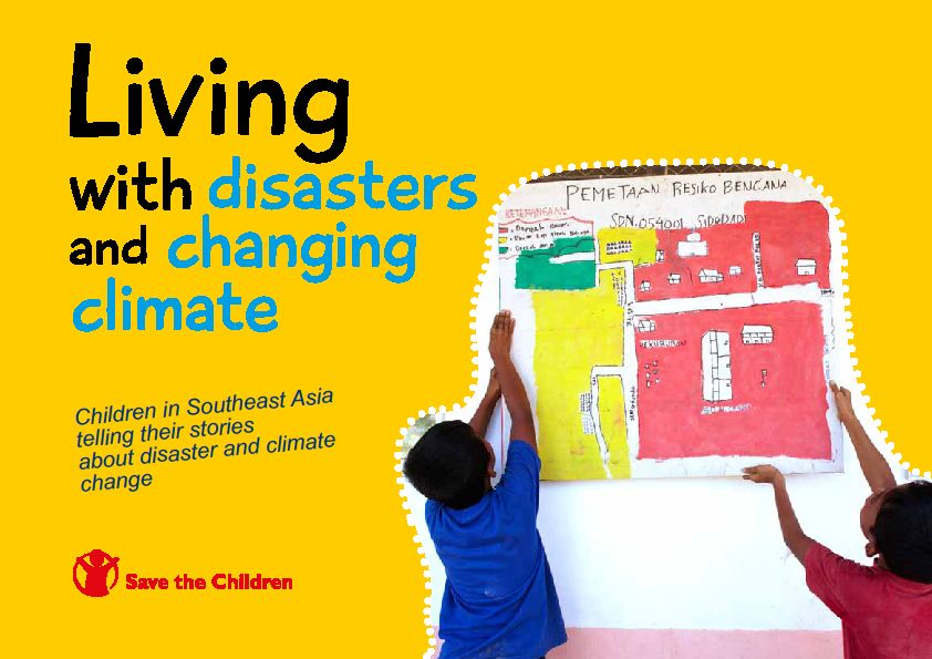
‘Living in the World of Disasters and Changing Climate’, published by Save the Children, is about children, disaster risk reduction, and climate change. It is a collection of children’s stories and statements about their views on disasters and climate change and their impact on the children’s lives, and how they can do something about it.
” Children should not be seen as victims, but actors in addressing the impacts of natural disasters and climate change on their lives and the life of their community. Policy makers and local authorities need to listen to children and see them as part of the future solutions. Children need to be involved in initiatives to build up their knowledge and resiliency thereby reducing the impacts of disasters and climate change, especially on the most vulnerable. “
Stories were collected from both primary and secondary sources. Interviews and focused-group discussions were conducted with children and adults in five communities in Thailand and four communities in Indonesia. Case studies were also collected from Vietnam and the Philippines. Programme documents and reports were used as secondary resources.
Children interviewed for this book have experienced different levels and frequencies of disasters and effects of climate change. While their voices do not represent the voices of all children in the Southeast Asia region, the book attempts to highlight common concerns amongst children who have experienced disasters and climate change. The fact is that children want and can take action to reduce the risks of disasters and climate change on themselves and their communities.
Save the Children
TOKYO, March 1 (Reuters) - Japan’s weather agency apologised on Monday for “crying wolf” when it urged some 1.5 million people to evacuate ahead of a possible major tsunami, only to find the waves that finally hit were far smaller than feared.
Experts defended the agency’s decision to warn that waves of 3 metres (9 ft 10 in) or more might strike Japan’s Pacific coast after a huge earthquake hit Chile, but acknowledged the risk of making residents blase about the danger next time.
“In the end, (the warning) was a bit excessive. I would like to apologise for the fact that the warning lasted so long,” Jiji news agency quoted Japan Meteorological Agency official Yasuo Sekita as telling a news conference after all warnings and advisories had been lifted, some 25 hours after the first alert.
Tsunami warnings are common in Japan, one of the world’s most earthquake-prone countries, but Sunday’s alert was the first for a major tsunami in 17 years and only the fourth since 1952.
The alert came after the Pacific Tsunami Warning Center (PTWC) had issued a Pacific-wide warning that included Hawaii and stretched across the ocean from South America to the Pacific Rim.
“I don’t question the wisdom of their warning. The key thing to remember is that they cannot underwarn. That is not an option,” Dailin Wang, an oceanographer at the PTWC, told Reuters.
Predicting the height of a tsunami is a complex task that requires not only knowing the quake’s magnitude but harder-to-grasp information about the impact on the sea floor and detailed data about the coastal areas that could be hit, Wang said.
Still, warnings of impending disaster that don’t pan out could encourage people to ignore future alerts, he said.
“If we do that all the time, we cry wolf and lose credibility,” Wang said. “We have to improve.”
Japanese are already fairly immured to tsunami warnings, despite past tragedies, including one that killed 140 people 50 years ago after a massive quake struck Chile.
On Sunday, only about 6 percent of residents in areas warned of waves of 3 metres or more evacuated, a Yomiuri newspaper survey showed.
“Citizens were not sufficiently aware of the danger of tsunami,” said Chief Cabinet Secretary Hirofumi Hirano.
“We don’t know when a tsunami will occur again, so together with local authorities we must review this problem,” he said.
* Storms kill up to 50 in France, 3 in Spain, 2 in Germany
* French coastal villages flooded after sea walls collapse
* Havoc in European rail network, flights cancelled
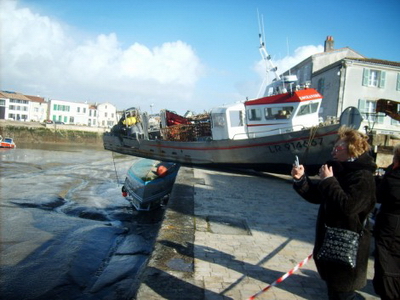
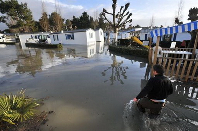
PARIS, Feb 28 (Reuters) - Storms swept through western Europe at the weekend, killing up to 50 people in France and threatening further damage as powerful winds and torrential rains moved north, officials said.
The storms ripped through cities, uprooting trees and street signs, wreaking havoc on rail networks and forcing hundreds of flights to be cancelled at airports like Paris and Frankfurt.
Three people were killed in Spain, two in Germnay and one in Portugal, but France was the worst hit as heavy rains, strong gusts of wind and high tides destroyed Atlantic coast sea walls, killing 25 people in the town of l’Aiguillon sur Mer alone, the mayor told French television.
“It is a natural catastrophe,” French Interior Minister Brice Hortefeux told BFM TV, estimating the total death toll in France at between 45 and 50 and warning that high tides could cause further damage.
Hortefeux said the French government had set aside 1 million euros in immediate relief aid and Budget Minister Eric Woerth issued a statement saying victims could seek tax relief.
The French regions of Vendee and Charente Maritime bore the brunt of the storm and were placed on flood alert along with parts of Brittany.
But centuries-old trees were also uprooted in the gardens of the Versailles palace near Paris, according to France Info radio.
Weather forecasters said the storm, named Xynthia, had moved up to northeast France and Belgium and would hit Denmark next. Meteo France said the storms seemed less fierce than those that battered France in Dec. 1999, killing 92 people.
SEEKING REFUGE ON ROOF
“Policemen are currently touring flooded houses and some of their inhabitants were found drowned,” said Frederic Rose, cabinet head of the Vendee Prefect.
A woman in l’Aiguillon sur Mer in Vendee, where a sea wall collapsed, told France’s M6 television she swam out of her house through the bathroom in the middle of the night to join neighbours on their roof.
A man in Loire-Atlantique, who spent the night on the roof of his restaurant, said: “It was as if we were on an island.”
Two people were killed near the northern Spanish city of Burgos when their car hit a fallen tree and a woman died when a wall fell on her in northwestern Spain, authorities said.
Unusually strong winds also uprooted trees in many parts of Portugal and heavy rain swelled rivers, prompting flood warnings in low-lying parts of Porto along the Douro River estuary. A girl of 10 died when she was hit by a falling tree.
In Germany, authorities said a 69-year-old man was killed by a falling tree while hiking in the state of Hesse. A 74-year-old man was killed and his wife critically injured in the southwestern state of Baden-Wuerttemberg when a tree fell on their car, according to media reports.
Rail travel was severely disrupted in the three western states of Hesse, Rhineland-Palatinate and Saarland due to trees falling on overhead power lines.
PLANES, TRAINS DELAYED
Frankfurt airport was forced to cancel about 10 percent of its flights, an airport spokesman said.
Air France said it had cancelled more than 100 flights on Sunday and more than half of all flights departing from Paris were significantly delayed, Aeroports de Paris said, while high-speed TGV train service was severely delayed due to branches and other debris obstructing the rail network.
By late Sunday, some 500,000 people in France were without electricity, said ErDF, the distribution arm of French energy group EDF, with Brittany and central France the hardest hit. [ID:nLDE61ROBF]
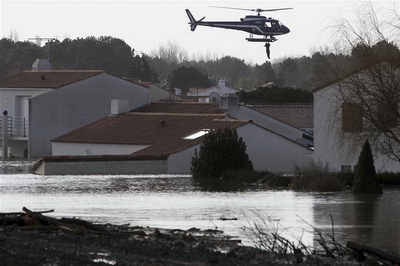
Much of England and Wales was on flood alert on Sunday, with further prolonged heavy rain and strong winds expected after torrential downpours overnight.
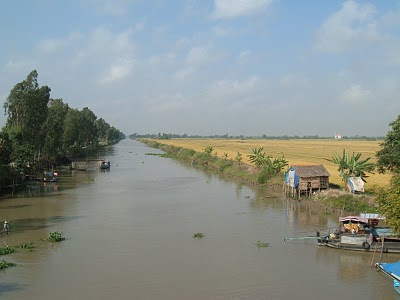
VietNamNet Bridge – Park rangers have sounded a nationwide forest fire red alert as a drought has desiccated the Red River in the north and pulled saline water deep into the parched Mekong Delta.
A boat is stranded in Quyt Stream, a tributary of the Hong (Red) River in Hanoi.
“Eight forest fires broke out over the Tet holidays, including one that destroyed more than 1,000 hectares at Hoang Lien Forest in Lao Cai and Lai Chau provinces,” said Ha Cong Tuan, head of the Forest Protection Department under the Ministry of Agriculture and Rural Development.
“Forest fire alerts have been set to the highest level in many places where forest areas could easily be caught up in bushfires that would be extremely difficult to extinguish.”
Tuan said seven provinces had increased the alert to level 5, the highest alert for forest fire threats, including Kien Giang, Ca Mau and An Giang in the Mekong Delta, and Kon Tum, Gia Lai and Lam Dong in the Central Highlands and Son La in the north.
He said the cause of the alert was El Nino’s dry weather, which has pushed temperatures 2-3 degrees Celsius higher than usual. He also said a short rainy season with little perspiration and the early-arrival of the dry season this year had contributed to the problem.
“More than 70 percent of forest fires in the past were caused by slash-and-burn farming. Meanwhile, children burning firewood for heat as they watch over grazing cattle in the forest has also been a major cause,” he said.
Le Minh Hoang, director of U Minh Thuong National Park in Kien Giang Province, said his agency had also raised its fire alert as water levels in mangrove forest areas had dropped dramatically recently.
The nearby U Minh Ha National Park also reported more than 2,000 hectares of forest were at risk of fire and another 1,000 hectares would be added to this list by the next week as the drought has yet to reach its peak.
Out to dry
Water levels in the Hong (Red) River – one of the major rivers in the north – reached a measly 10 centimeters on February 21 and this low could reoccur next week, a senior meteorologist said.
Nguyen Lan Chau, vice director of the National Center for Hydro-meteorological Forecasting, said this was the lowest the river had fallen since authorities began keeping river water level records in 1902.
“The Red River water level has never been this low. The previous record was 0.7 meters in 2009,” she said.
She said the water level had increased to around one meter over the past few days after several upstream hydropower reservoirs discharged water for irrigation.
However, she warned that if the reservoirs don’t release more water, a drought would keep the river humble until mid-March when the rainy season comes.
Dang Duy Hien of Vinh Phuc Province Irrigation Department said the province had taken the heaviest hit from the drought as nearly 7,000 hectares of rice fields now have no water for the new season.
On Wednesday, Minister of Agriculture and Rural Development Cao Duc Phat instructed provincial agriculture agencies to ensure enough water for agriculture irrigation by better management of water supply and pumping systems.
Although the drought is far from over, the Mekong Delta has already suffered the severe encroachment of saline water in several provinces.
Le Thi Xuan Lan of the Southern Meteorology Station said sea water had reached 30 kilometers inland in Ben Tre Province.
“The salt grades in river water have also increased remarkably in Tra Vinh, Long An, Soc Trang, Kien Giang and Ca Mau provinces,” she said.
VietNamNet/Thanh Nien
* Quake kills at least 214 people in central Chile
* Buildings toppled, bridges and roads destroyed
* Operations halted at two major copper mines
* Tsunami kills at least 3 on Robinson Crusoe island (Updates with death toll rising; adds quotes, details)
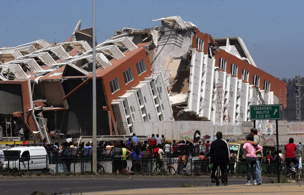
CONCEPCION, Chile, Feb 27 (Reuters) - One of the world’s most powerful earthquakes in a century battered Chile on Saturday, killing at least 214 people, knocking down buildings and triggering a tsunami that threatened Pacific coastlines as far away as Hawaii and Russia.
Buildings caught fire, bridges collapsed and debris blocked streets across swathes of central Chile, but the initial death toll was relatively low from a quake packing many times more power than the one that devastated Haiti last month.
A 15-storey building collapsed in Concepcion, the closest major city to the epicenter, and overturned cars lay scattered below a fallen overpass in the capital Santiago. Telephone and power lines went down, making it difficult to assess the full extent of the damage and loss of life.
The government said at least 214 people were killed in the 8.8-magnitude quake, which struck at 3:34 a.m. (0634 GMT), sending people rushing from their beds and onto the streets in fear, hugging each other and crying.
“It came in waves and lasted so long. Three minutes is an eternity. We kept worrying that it was getting stronger, like a terrifying Hollywood movie,” said Santiago housewife Dolores Cuevas.
One emergency official said the number of deaths was unlikely to increase dramatically, and a U.S. Geological Survey researcher attributed the low toll to Chile’s solid building standards.
But it was the fifth-largest earthquake since 1900 and dealt a blow to the economy and infrastructure of the world’s No. 1 copper producer and one of Latin America’s most developed and stable countries. [ID:nN27181062]
“This will be a major blow to the country’s infrastructure; there has been major damage to roads, airports, which are now suspended, ports and also in housing,” Chilean President-elect Sebastian Pinera said.
The quake halted operations at two oil refineries and two major copper mines [ID:nN27177467] and the government said an estimated half a million homes were severly damaged.
President Michelle Bachelet said a huge wave hit the Juan Fernandez islands, an archipelago where Scottish sailor Alexander Selkirk was marooned in the 18th century, inspiring the novel Robinson Crusoe.
“There was a series of waves that got bigger and bigger, which gave people time to save themselves,” pilot Fernando Avaria told TVN television by telephone from the main island. Three people were killed and four missing there, he said.
Tsunami warnings were posted around the Pacific, including the U.S. state of Hawaii, Japan and Russia. The U.S. Navy said it was pulling six ships out of Hawaii’s Pearl Harbor ahead of the tsunami, which was expected to hit the island at heights of up to 8 feet (2.4 meters).
Unusually big waves battered Ecuador’s Galapagos Islands, where residents were moved to higher ground as a precaution.
Bachelet said residents were evacuated from coastal areas of Chile’s remote Easter Island, a popular tourist destination in the Pacific famous for its towering Moai stone statues.
The U.S. Geological Survey said the earthquake struck 70 miles (115 km) northeast of Concepcion at a depth of 22 miles (35 km).
An earthquake of magnitude 8 or over can cause “tremendous damage,” the USGS says. The Jan. 12 quake that devastated Haiti’s capital Port-au-Prince and killed well over 200,000 people was measured as magnitude 7.0.
DAMAGE TO CAPITAL, MAJOR MINES
Chile’s capital of Santiago, about 200 miles (320 km) north of the epicenter, was also badly hit. The international airport was closed for at least 24 hours as the quake destroyed passenger walkways and shook glass out of doors and windows.
“I thought I’d blown a tire ... but then I saw the highway moving like it was a piece of paper and I realized it was something much worse,” said one man who was forced to abandon his car on a wrecked highway overpass.
Codelco, the world’s largest copper producer, suspended operations at its El Teniente and Andina mines, but reported no major damage and said it expected the mines to be up and running in the “coming hours.”
Production was halted at the Los Bronces and El Soldado copper mines, owned by Anglo American Plc, but Chile’s biggest copper mine, Escondida, was operating normally.
Chile produces about 34 percent of world supply of copper, which is used in electronics, cars and refrigerators.
Local television showed a building in flames in Concepcion, one of Chile’s largest cities with around 670,000 inhabitants. Some residents looted pharmacies and a collapsed grains silo, hauling off bags of wheat, television images showed.
At least 269 prisoners took advantage of the quake to escape from a prison about 250 miles (450 km) south of Santiago, police said. Twenty-eight of the inmates were captured and three shot.
Broken glass and chunks of concrete and brick were strewn across roads and several strong aftershocks rattled jittery residents in the hours after the initial quake.
“It was like we were being shaken around in a box,” said Claudia Rosario, a 27-year-old receptionist in Temuco, about 175 miles (280 km) south of Concepcion. She said residents there were without water and electricity.
“But thank God it was just small things (broken). It could have been worse.”
There were blackouts in parts of Santiago. Emergency officials said buildings in the historic quarters of two southern cities, mainly made of adobe, had been badly damaged and local radio said three hospitals had partially collapsed.
The magnitude 9.5 earthquake of 1960, the largest earthquake worldwide in the last 200 years, spawned a tsunami that engulfed the Pacific Ocean. About 1,600 lives were lost in Chile and the tsunami took another 200 lives in Japan, Hawaii and the Philippines
In 1960, Chile was hit by a 9.5-magnitude earthquake, one of the biggest ever recorded. It devastated the city of Valdivia, killed 1,655 people, and sent a tsunami that continued as far as Hawaii, Japan and the Philippines.
Saturday’s quake shook buildings as far away as Argentina’s Andean provinces of Mendoza and San Juan. A series of strong aftershocks rocked Chile’s coastal region from Valdivia in the south to Valparaiso, about 500 miles (800 km) to the north.
President Barack Obama called Bachelet and said the United States stood ready to help Chile. He also urged Americans to heed warnings about a possible tsunami that could affect the U.S. West Coast and Hawaii.
Secretary of State Hillary Clinton was due to visit Chile on Tuesday on a Latin American tour.
HANOI, Feb 27 (Reuters) - A Vietnamese woman who slaughtered and processed sick poultry has died from bird flu, the first fatality from the avian influenza virus this year in Vietnam, the Health Ministry said.
The 38-year-old woman died on Tuesday in a hospital in the southern Mekong Delta province of Dong Thap after fighting the H5N1 virus for 10 days, the ministry said in a statement seen on Saturday.
She is Vietnam’s second human infection reported this year and the first to have died from bird flu, which thrives best in cold weather and during the peak time of bird transportation, such as this month’s Tet festival to mark the Lunar New Year.
Earlier this month a three-year-old girl in the central province of Khanh Hoa recovered from bird flu, the Health Ministry said.
Vietnam has confirmed 114 human infections of the H5N1 virus since 2003, 58 of them fatal, the ministry said.
It is the second highest toll after Indonesia’s 134 deaths among the 15 countries on bird flu world map drawn by the World Health Organization.
Experts fear that the virus might mutate into a form easily passed from human to human, sparking a pandemic which could kill millions.
In order to help Vietnam respond and adapt to climate change, Japan will give Vietnam a preferential loan of 450 million USD, Denmark pledged to support with 53 million USD, and the World Bank and UNDP are also committed to help Vietnam financially.
Back from the UN summit on climate change in Copenhagen, Minister of Natural Resources and Environment, Pham Khoi Nguyen, said the Prime Minister Nguyễn Tấn Dũng and high-level representatives from the Government of Vietnam have secured a number of important contributions to help the country combat climate change.
Resulting from several bilateral and multilateral meetings, Vietnam ensured a number of encouraging commitments from various donors. Denmark will support Vietnam with 53 million USD, UNDP with 8 million, and Japan will give Vietnam a preferential loan of 450 millions USD. The World Bank will also support Vietnam financially.
Above that, The Netherlands will assist Vietnam in the consolidation of the sea dykes; Denmark will help with the medical waste treatment system in Hanoi and Ho Chi Minh city and the United States will support Vietnam with the upgrade of meteorological monitoring and surveying, and how to deal with high tides in the southern provinces.
Mr Nguyên also stressed that, on the side of Vietnam, as one of the most affected countries by sea level rise, we should continue to work on the implementation of the national target program to respond to climate change (from December 2008).
Vietnam has set the objective of 3-5 billion USD to be needed from now till 2015, to respond to climate change.
NCHMF
CIUDAD DE LA COSTA, Uruguay, Feb 25, 2010 (Tierramérica) - More and more Uruguayans are keen on building ecological homes. The problem is that there is hardly any market or specialised labour for what is known as “bio-building.”
Homes made from earth mean energy savings and contribute to fighting climate change, because their very construction emits less greenhouse gas than the usual commercial building techniques.
Inside these homes there is a pleasant environment, insulated from extreme temperatures and humidity. But perhaps most important is that they allow people to build their homes and to produce the necessary components themselves - making the dwellings more economical.
All told - with labour costs, architectural consulting and other expenses -, an earth home in Uruguay costs between 500 and 600 dollars per square metre, while a standard cinder-block house costs almost twice as much, at 900 to 1,000 dollars per square metre.
It was once common in the countryside of this small South American country between Brazil and Argentina for houses to be built with the materials provided by nature: dirt, wood, and straw. Those techniques, which are now known as bio-construction or bio-building, were passed down from generation to generation, and even today there are a few who maintain that tradition.
In the 1990s, a group of architects here began studying the use of earth in construction, at the same time the ideas and techniques were being incorporated into the curriculum at the University of the Republic’s school of architecture.
This meant that the approach could be replicated in different parts of the country - but they were isolated projects, and the government showed little interest in supporting the efforts.
Over the past 15 years, around 100 of these bio-homes have been built with the participation of the architects, and another 100 by the residents themselves.
The demand for environmentally sustainable construction techniques is on the rise, but there are no policies to guide it, no market for production and sales of eco-materials, and few construction workers familiar with the techniques.
Those are the basic elements needed to promote alternative construction, according to architect Rosario Etchebarne, an expert in bio-building and professor and researcher at the University of the Republic’s school of architecture.
“There is great public demand, and many people are interested in experimenting. But the authorities are still hesitant because we need technical standards for the construction processes, and they fear the experimental approach,” she told Tierramérica.
Etchebarne explained the three most popular techniques for building a bio-home: adobe, or sun-dried bricks; compressed earth blocks (CEB) produced by a machine; and what is known here as “fajina”, a wood frame filled in with soil stabilised with straw and other components.
“Bio-construction incorporates many concepts of sustainability. The basis of everything is that there are energy savings,” Etchebarne said.
“We would be helping to mitigate climate change because we would not be emitting any carbon dioxide into the environment; the amount of cement used is minimal,” she added.
One of Uruguay’s recent experiences in earth construction is Guyunusa, a housing cooperative in Ciudad de la Costa, in the southern Uruguayan department (or province) of Canelones, on the River Plate (Río de la Plata). The 10 homes, which were built using mud, were paid for with a loan from the Ministry of Housing.
“We chose this type of construction because we wanted cheaper and healthier housing. We researched different techniques and concluded that an earthen home was healthier and better insulated, more economical and within everyone’s means,” Silvana Delfino, a member of the cooperative, told Tierramérica.
“It’s nothing new: human beings have lived in earth homes here and in other parts of the world,” she added.
The Guyunusa housing complex also includes an ecological sanitation system. It is located in an area that is not connected to the sewage network, so the cooperative created its own, with financing from the United Nations Development Programme (UNDP).
According to Delfino, the idea behind the cooperative is “to show that with little money we can have decent housing that respects the environment.”
On the outskirts of Montevideo, in the self-managed Comunidad del Sur and La Wayra, several families built their ecological homes with the help of German architect Heiner Peters, who visited Uruguay to share his expertise.
This approach has also been used for building summer homes near the sea, as well as large houses on rural estates.
“There is no great mystery with this type of construction. It used to be that people settled in a place and built their homes with what they found around them. The problem is, perhaps, that we have ‘unlearned’ some things,” Hugo Costa, who lives in La Wayra, told Tierramérica.
* Seasonal rains and hurricanes spell trouble
* More robust housing needed but time is short
LONDON, Feb 25 (Reuters) - Seasonal rains and hurricanes spell trouble for Haiti in the best of times, but with hundreds of thousands of people living in flimsy makeshift shelters after last month’s earthquake, this year the dangers are much greater.
The rainy season begins in earnest in early April and the hurricane season in early June, according to the World Meteorological Organisation (WMO). Both can be deadly.
“If a hurricane hits Haiti head on, the loss of life will be severe and every temporary housing camp will be wiped out,” Cameron Sinclair, co-founder of non-profit design and building group Architecture for Humanity, wrote in a blog.
Margareta Wahlstrom, U.N. Special Representative of the Secretary-General for Disaster Risk Reduction in Geneva, offers a similar warning for the Haitian capital.
It bore the brunt of the Jan. 12 earthquake, which has killed up to 300,000 people.
“Port-au-Prince is built on vulnerable small slopes and mountains. With the rains, these slopes start softening up and cause mudslides like we have seen in the past, causing schools to collapse and more deaths,” she told Reuters AlertNet.
A series of storms in Haiti in 2008 already showed the extent of damage they can cause, even to sturdy buildings. More than 800 people were killed and nearly 1 million left homeless or in dire need of help.
Haiti is extremely vulnerable to floods and mudslides because most of its hillsides have been stripped bare.
Cutting down trees to make charcoal to sell for fuel is a last resort for many rural Haitians who have no other income between harvests.
There is no talk in the Haiti aid community of building enough durable housing before the storms start and no mention so far of evacuation plans in case of floods or mudslides.
“We have a huge challenge in terms of just providing emergency shelter—something that we feel that if we put all of our weight behind, as we are doing right now, we will be able (to do),” said Kristen Knutson, a spokeswoman for the U.N. office that is coordinating the international relief effort, in a telephone interview from Haiti.
She added that aid groups were for now focusing on providing plastic shelter materials to earthquake survivors and that more robust housing would be needed in the longer-term.
The International Federation of Red Cross and Red Crescent Societies (IFRC), which is coordinating all shelter-related aid work in Haiti, is so far building only one model transitional house and hopes construction of more houses will begin before the rainy season.
“MINIMAL PROTECTION”
Beyond distributing waterproof shelter materials, aid agencies are also working to improve sanitation and health care—all essential in wet conditions which help infections spread.
“Neither tents nor tarpaulins, however, will provide more than minimal protection from the Haitian rainy season which peaks in May, when Port-au-Prince gets an average 230 mm of rain and sometimes as much as 50 mm in two hours.
The hurricane season, which begins later in the year, is of special concern,” IFRC said in a statement.
When asked for more information, including on evacuation plans, an IFRC spokesman in Haiti declined to comment further.
The WMO has also been asking Haitian authorities and some aid agencies on the ground whether it would be possible to anticipate floods and move the displaced people—many of whom have camped out in low-lying planes and near the sea—to safer ground, said Maryam Golnaraghi who heads the disaster risk reduction programme at the U.N. weather body.
“I do not know the answer to that,” she told Reuters AlertNet. Before any evacuation can begin, reliable and consistent forecasts of extreme weather must reach the government and relief groups quickly.
In Haiti, that is difficult as the earthquake shattered its weather stations and now several countries are supplying meteorological information to the country.
To prevent any confusion, the WMO is working with Haiti’s authorities to ensure that all weather forecasts are channelled through Haiti’s single official meteorological service.
Another challenge is disseminating the information, now that only a fifth of all media in Haiti are working, Golnaraghi said.
As those aims are achieved one by one, Haiti will become better prepared for the stormy season. But time is short and the number of people at risk enormous.
“We recognise that this is minimal perfection,” said Knutson from the U.N. Office for the Coordination of Humanitarian Affairs (OCHA).
In Phu An (Thu Thien Hue) one of the 16 houses rebuilt is nearly completed. Cconstruction works for all houses will be finished before the end of March. The supply of equipment for fishing to the 200 families affected by the cyclone Kettsana will take place at the beginning of March 2010.
Deputy Prime Minister Hoang Trung Hai on February 23 met with the National Steering Committee for Flood and Storm Control and the National Committee for Search and Rescue.
He praised the agencies’ efforts in dealing with storms and floods in 2009, noting that updated information systems have improved the coordination of rescue and relief efforts.
Mr. Hai said the first priority of the agencies should be to minimise losses due to natural disasters.
He said that to cope with global climate change, relevant departments and localities should focus on improving their information systems and build a suitable organisation model to meet a growing demand for disaster preparedness, disaster prevention and disaster relief.
VietNamNet Bridge – Despite earlier tidal rises, on February 22, 7pm, the water in the Red River was only 10cm high, the lowest level on records.
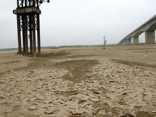
The 3.7km Vinh Tuy Bridge across the Red River has become a viaduct with only one pile under water.
Due to the drying up since November 2009, sand-banks amid the river are rapidly expanding and become green grass fields.
Below the Vinh Tuy Bridge, Hanoi, is a vast sand-bank of thousands of meters. This modern bridge, which was inaugurated over 4 months ago, now has only one pile under water. The sand-bank under the Vinh Tuy bridge has become a sand mining site.
As of February 18, a section of river near the Long Bien Bridge has been dredged. This work will be carried out in 26 days to make a passage of 1.5m depth for boats. However, the water level has continued to fall.
Le Van Luong, director of the Waterway Management JS Company No. 6, the firm that is doing the dredging, complained: “It is useless to dredge the river when the water level falls below 10cm and rises to only 15-20cm”. Luong said that the waterway route on the Red River is paralyzed. Only small, empty boats can run in short passages.
Nguyen Lan Chau, deputy director of the National Hydrometeorology Forecast Centre said that due to lack of rain in the north, the water levels on northern rivers continue to fall. Reservoirs are about to discharge water for cultivation in the next several days and the Red River will reach 1.3-1.5m. However, the river will get exhausted again until mid-March 2010.
Fourth graders around the country will be taught how to swim to reduce the number of drownings in the country, according to a recent Ministry of Education and Training directive.
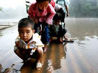 Children from in a mountainous village in Lang Son Province cross a river twice a day to go to school.
-
The ministry this week sent a note to city and provincial Departments of Education and Training, asking them to try teaching swimming for primary students, especially those in fourth grade, local newswire VietnamNet said Thursday.
Schools were asked to train their physical education teachers and build and share swimming pools, depending on the amount of space and finances available.
The children should be taught swimming on the weekend, during summer vacation or in physical educations classes if possible, the ministry said in the note.
The ministry will subsequently take into account swimming instruction when evaluating the performance of the city/provincial education departments.
Story from Thanh Nien News
Published: 12 February, 2010
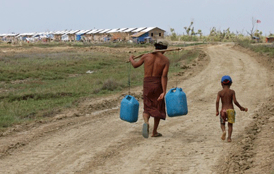
A man carries jerrycans in April 2009 toward a recently-built housing estate for survivors of Cyclone Nargis in Pyinsalu town in the Irrawaddy delta
GENEVA—The International Organization for Migration (IOM) says 500,000 people in Burma are still homeless after a devastating cyclone swept across the southwest of the country nearly two years ago.
IOM spokesman Chris Lom says the affected people have not been able to buy supplies to rebuild their houses because they need to spend the money on food.
He says the agency’s reconstruction program in the Irrawaddy delta is running out of money.
Lom said on Tuesday the agency is appealing for US $17 million to give basic shelter to about 250,000 people in the region. He said other aid agencies are trying to set up shelter for the rest of the homeless.
Cyclone Nargis killed nearly 140,000 people in the South Asian nation in May 2008 and left some 2.4 million without a home.