Sunday, July 11, 2010
Making Cities Resilient: “My city is getting ready” Disaster Reduction UN ISDR Campaign 2010-2011
Map / July 2010
Map / July 2010
The following article has been recently published:
Birkmann, J. and K. von Teichman. 2010. “Integrating disaster risk reduction and climate change adaptation: key challenges—scales, knowledge, and norms.” Sustainability Science 5:171-184.
The abstract begins “Statistical data shows that the increase in disasters due to natural hazards over the past 20 years has, for the most part, been caused by meteorological and hydrological events. This increase has been largely assigned to climate change [Centre for Research on the Epidemiology of Disasters (CRED), 2010, ”]http://www.emdat.be/Database/Trends/trends.html]”.
The introduction elaborates that “Hydro-meteorological disasters increased by more than 100%, from about 100 in 2004 to more than 200 in 2006, while the number of geophysical disasters, such as earthquakes (including tsunamis) and volcanic eruptions, has remained steady throughout the last decade (CRED 2010). Hence, there is an obvious relationship between climate change and the increase in climate-related hazards, implying, in general, that a higher disaster risk must be asserted (McBean and Ajibade 2009, p. 181)”.
The CRED 2010 reference is to a website (non-peer reviewed) that did not work when I tried to access it. McBean and Ajibade 2009 is more nuanced in its approach than is presented in this text, e.g. McBean and Ajibade 2009, p. 181 write “some studies have identified trends in numbers of intense typhoons and some have found no evidence of trends”.
The scientific flaws in the above quotations from the “Sustainability Science” paper are evident, which I list below. None of these deny that climate change is an immense, global disaster that must be tackled urgently. As well, the rest of the paper has parts that are more realistic than the abstract and introduction, but yet still fail to factor in much of the disaster risk reduction literature, such as past work lambasting both the return-to-normal paradigm and the disaster cycle—and, more importantly, providing strong alternatives to those approaches. Similarly, the discussion claiming that climate change has taken a global view that disaster risk reduction has not (e.g. “the DRR community focuses primarily on local vulnerabilities and risks of specific areas, hazards, and groups of people potentially or actually affected”) neglects extensive work on global-scale disasters, global-scale disaster responses, and global scale vulnerability reduction, from meteorite strikes to pandemics. Meanwhile, the statement “early warning systems, so far applied only to sudden-onset hazards, should also be developed for creeping hazards” does not acknowledge authors such as Glantz and Wilhite who have already done so.
Given how much scientific evidence exists regarding the disaster of climate change and the need to adopt countermeasures now, why exaggerate climate change’s influence? There is no need to overlook the points detailed in this email to make climate change more dramatic. Accepting the science detailed in this email does not diminish the importance and urgency of climate change. Climate change is dramatic enough without needing to exaggerate.
Similarly, it is easy to criticise without providing alternatives. Alternatives are provided at http://www.ilankelman.org/articles1/daeditorial2008.pdf and the Policy Arena at http://www3.interscience.wiley.com/journal/123300554/issue .
Why be so desperate to attribute too many problems to climate change?
How can we ensure that the debate remains based on science?
Some scientific concerns with the text quoted above from the “Sustainability Science” paper:
1. Many factors contribute to changes witnessed in climate-related hazards. No evidence is presented for decoupling the climate change signal from other factors.
2. The implicit, perhaps inadvertent, assumption is made that hazards dominate the disaster signal; i.e., those sentences do not discuss changes in vulnerability over the reported time period. That contradicts the past 40+ years of vulnerability literature, including for example how river floods have increased due to human influences on rivers. Also on that note, the article states that it did “A review of existing literature on the topic”, yet a long list of key vulnerability authors and ideas are missing from the reference list. See the critique at http://www.islandvulnerability.org/docs/vulnrescritique.pdf along with http://www.ilankelman.org/miscellany/DisasterLexicon.rtf which list numerous vulnerability authors and ideas that are often overlooked by climate change literature. The vulnerability paradigm, and the authors and ideas quoted, in no way dismiss input into disasters from hazards, including climate change. A balance between hazards and disasters always needs to be articulated.
3. I would be curious to have some commentary from statisticians regarding drawing conclusions by comparing 2004 with 2006, not to mention trying to extrapolate trends over centuries based on ten years of data.
4. No comment is made regarding possible changes in reporting structures over the analysed time period that could influence the data.
5. Climate-related hazards include cold waves, avalanches, and rainfall-induced landslides. The literature on climate change and those hazards lists numerous, detailed factors at various scales that could increase or decrease the incidence of those hazards due to climate change.
Ilan Kelman
LCA Linking Climate Adaptation Network - linking practitioners, researchers, NGOs and policy-makers working on climate adaptation issues around the world. The LCA Network is run by IDS, at: http://community.eldis.org/lca/
Source: United Nations Office for the Coordination of Humanitarian Affairs - Integrated Regional Information Networks (IRIN)
Date: 08 Jul 2010
JOHANNESBURG, 8 July 2010 (IRIN) - The La Niña phenomenon has officially arrived and disaster response teams around the world might need to brace themselves for heavier monsoons, bigger and more frequent hurricanes, and angrier cyclones.
“There is global consensus that we are at the beginning of a La Niña, but we cannot pronounce the intensity of the event yet - we have to wait for it to evolve,” said Rupa Kumar Kolli, Chief of the World Climate Applications and Services Division at the World Meteorological Organization (WMO).
La Niña is characterised by unusually cold ocean temperatures in the eastern equatorial Pacific Ocean; El Niño is characterised by high temperatures, the US government’s National Aeronautics and Space Administration says on its website.
The colder-than-normal ocean temperatures prevent rain-producing clouds from forming over the eastern equatorial Pacific region, including the open ocean south of Mexico and Central America, but enhance rainfall over the western equatorial Pacific region of Indonesia, Malaysia and northern Australia.
This in turn affects the jet streams, or strong wind-flows, in the upper levels of the atmosphere and the behaviour of storms outside of the tropics in both the northern and southern hemispheres. In short, La Niña is a global phenomenon.
The National Hurricane Centre at the US government’s National Oceanic and Atmospheric Administration (NOAA) has been expecting a La Niña to occur, and by May 2010 predicted a 70 percent chance that there would be 14 to 23 named storms, with wind speeds of more than 62km per hour. This is far more than the average of 11 named storms during the hurricane season in the Atlantic region, which began in June.
The first hurricane of the season, Alex, hit Mexico on 30 June. NOAA said it was the first hurricane to be recorded in June in the Atlantic Basin since 1995, and the strongest in that month since 1966.
On the Caribbean side of Central America, La Niña is bad news for vulnerable islands such as Haiti, which is still recovering from the earthquake that struck it in January 2010.
Africa
Cobus Olivier, a scientist in the Prediction Research section of the South African Weather Service, said the possible impact of La Niña on Africa, and particularly southern Africa, was unclear. “At the moment the La Nina event is only starting out and will most probably take a month or two before it’s considered a true La Niña event.”
He said it was very difficult to predict the impact as this could vary within the African region and from one La Niña event to another. La Niña is usually associated with more rain, but an analysis of rainfall patterns for African countries south of the equator tells a different story.
Olivier and his colleagues used rainfall data collected during La Niña events from 1961 to 2002, for the months of August, September and October, when the event is expected to be more pronounced.
“Uganda and the southern parts of Sudan usually seem to have wetter conditions during La Niña ... but parts of Angola, DRC [Democratic Republic of Congo], Mozambique, Tanzania, Kenya, Somalia and Madagascar tend towards drier conditions,” he said.
In South Africa the situation is “very variable”, but “Generally it looks like we may have spring rains [in September-October], and this is also supported by our latest forecast.”
Southeast Asia
Meteorologists in Southeast Asia, where the monsoon season is underway, have predicted a normal monsoon, Kolli said. The region struggled with poor rains caused by an El Niño that affected food production in India, Pakistan, Bangladesh, Nepal, Vietnam, the Philippines and Thailand.
“But if the La Niña gets more pronounced, there is a stronger chance of monsoon depressions turning into cyclones that would affect Bangladesh and its surrounding areas [India and Myanmar], with heavier monsoons leading to flooding and mudslides.”
July is the time of year when cyclonic storms, known as typhoons in the northwest Pacific, start rolling in, but Kolli said there was not a “very strong association between the La Niña event and typhoons.”
LONDON (AlertNet) - Floods, storms and other natural disasters killed 10,655 people last year and disrupted the lives of 119 million but overall, there were fewer natural disasters in 2009 than in the previous year, a Brussels-based research group said.
New figures published by the Centre for Research on the Epidemiology of Disasters (CRED) showed a total of 335 natural disasters in 2009, compared with 350 in 2008 and an annual average of 392 between 2000 and 2008.
However, CRED cautioned against drawing any conclusions from the data, noting the absence in 2009 of a single so-called ‘mega disaster’ which typically leads to many more deaths, a bigger affected population and a deeper cost to the economy.
“Although 2009 was a year with relatively less human and economic impacts compared to previous years, it is difficult to identify clear trends over time,” CRED said in its report.
Last year all continents, apart from Africa, experienced a drop in the number of natural disasters compared to the annual average for the 2000-2008 period.
But Asia once again suffered the most, accounting for just over 40 percent of the world’s natural disasters, with the Philippines struck by 25 disasters alone.
CRED said the Sept. 30 earthquake that rattled Sumatra, Indonesia, caused the highest death toll of any natural disaster in 2009, with 1,117 people killed as well as 2.5 million affected.
Flooding in southern and central China in July impacted the biggest number of people - 39.4 million - while a storm that swept through France, Spain and Italy in January 2009, chalked up $5.1 billion of damage, the most caused by a single natural disaster in 2009.
CRED called on countries to be better prepared for the destructive impact of disasters.
“Although the natural disaster impact on human society in 2009 was relatively small compared to previous years, the consequences were critical to many families who lost their loved ones and livelihoods,” it said.
“Underlying factors and preconditions that make human populations vulnerable to disasters need to be addressed in order to mitigate impacts and create resilient and sustainable societies.”
Other findings from CRED’s Annual Disaster Statistical Review 2009 include:
* Last year’s disasters caused more than $41.3 billion of damage.
* Hydrological disasters including flooding accounted for 53 percent of the total number of natural disasters.
* The number of people affected by meteorological disasters such as typhoons rose by 220 percent compared to 2008.
* The number of reported climatological disasters, such as extreme temperatures, droughts and wildfires, was higher in 2009 than the previous year but lower than the annual average for the 2000-2008 period.
* In 2009 there were only 25 geophysical disasters reported compared to the 2000-2008 annual average of 37. Of these, 18 were earthquakes, four tsunamis, two volcanic eruptions and one a landslide.
See Report CRED 2009
Power shortage in the winter: blame it on the lack of water. Power shortage in the summer: blame it on low rainfalls.
It seems like the weather is now completely responsible for every power cut in the country.
State-owned Electricity of Vietnam earlier this month promised that the current power shortage would ease beginning in mid-June. But the power monopoly did not forget to throw in an “only if”, saying that it will only happen if rainfalls are plentiful and there are small floods.
Isn’t it kind of funny that the energy security of a nation has to depend on something as volatile as the weather? Power shortages have been an ongoing problem for many years, but the power sector is always innocent. The weather is the one to blame for everything.
But the fact is, however, our power shortage is the result of bad planning and a lack of vision.
The main sources of power in Vietnam are hydro and thermal power plants. Hydroelectricity is dependent on weather conditions while coal supplies for thermal power plants will run out someday – the country has already made plans for coal imports. So one way or another the power problem can only be solved when alternative energy sources are developed.
When proposals to produce wind power were made in the early 1990s, they were not supported because many people said it would be too expensive. But wind power development in many countries has proved this prejudice wrong. Wind power technology becomes cheaper every year and is not expensive compared with hydroelectricity, not to mention the environmental benefits.
Vietnam has a coastline of 3,200 kilometers and is considered to have the best potential for wind power production in Southeast Asia.
Of course it requires a lot of work to tap this potential, but it will be a huge waste if the country does not take wind power development seriously enough to solve the power shortage problem.
By An Nguyen
This year’s rain and storm season is expected to arrive late - and be even more unpredictable.
Low-pressure systems over the East Sea usually bring tropical storms and heavy rainfalls between May and June. However, so far, none had been reported, said the head of the National Centre for Hydro-meteorological Forecasting, Bui Minh Tang. He said that this could mean that when they did arrive, they would be far more complicated and could lead to serious flash flooding.
“And this year’s storm season is likely to last until the end of this year, just like in 1983 and 1998,” Tang warned. Large-scale flooding is now forecast for central and northern rivers from August to October and from July to November in the Central Highland region.
Tang warned people to prepare against sudden floods, storms and landslides in mountain areas. Head of the Department for Dyke Management and Flood and Storm Prevention Tran Quang Hoai said only limited work had been done this year. Hoai said the situation was getting worse, blaming urbanisation for encroaching on flood-drainage corridors. He said district-level authorities were the key to improving the situation.
The vice chairman of Phu Xuyen District People’s Committee in Ha Noi, Nguyen Dinh Chieu, suggested local authorities be regularly updated about storms. He also called for tighter management of dyke systems and sand exploitation along river banks.
The chairman of Thach Ha District People’s Committee, Do Khoa Van, said the State should give financial support to local authorities to consolidate dyke systems - and to supply rescue equipment.
Last week, 80mm of heavy rain caused flash floods in Tuong Duong District in central Nghe An Province. Initial losses were estimated at VND10 billion (US$526 million).
VietNamNet Bridge – Losses to drought are mounting daily in central Vietnam. The Ministry of Agriculture and Rural Development (MARD) has made an urgent report to the Prime Minister on July 1.
The outlines of the MARD report were briefed on July 1. Members of a MARD mission just returned from Vietnam’s central region confirmed that nearly 200,000 hectares of rice and vegetables are withering. Half of the area suffers from serious drought. At least 15,000 hectares of rice will be a dead loss.
Government meteorologist Tran Van Nguyen says that the central region is experiencing a temporary respite on July 1. However, scorching weather will return from July 3 for about a week. The highest temperature may hit 37-38°C.
A dry westerly from Laos will blow strongly in the next several days, intensifying the drying effect of the hot weather.
Rain will be very rare, nothing more than showers in the mountains.
Nguyen says such drought in central Vietnam has not been seen since 1998. The hot weather will continue until August.
Drought is also drying up also daily water supply. At least 40,000 households in nine districts of Binh Dinh province, on Quang Ngai’s Ly Son Island, and along the lower reaches of the Thu Bon river (Quang Nam) are living without adequate supplies of clean water.
At a meeting chaired by First Deputy Minister of Agriculture and Rural Development Bui Ba Bong on July 1, Pham Hong Quang, head of the mission to the central region, said that drought most serious in the north central region – the coastal provinces of Thanh Hoa, Nghe An and Ha Tinh.
Quang said that of more than 250,000 hectares of summer-autumn rice, 62,000 are seriously short of water, including 55,000 hectares in the aforementioned provinces. Another 70,000 hectares of ricefields have been left fallow because of drought.
On the central coast, 25,000 hectares of rice and 23,000 hectares of vegetables are reported to lack water. The worst hit provinces are Binh Dinh (6000 hectares), Quang Nam (5000 hectares), Khanh Hoa (5000 hectares), Phu Yen (2000 hectares) and Da Nang (700 hectares).
Quang forecast that if baking sun continues for another five to seven days, losses will rise considerably. Specifically, the north-central region would have to write off another 12,000 hectares rice while losses on the central coast will double to reach 45,000 hectares.
The hot dry weather has persisted for more than two months, drying up rivers, reservoirs and streams in the region.
Major rivers like the Tra Khuc (Quang Ngai), Vu Gia and Thu Bon (both Quang Nam) are all dry. The level of water in reservoir at Quang Ngai’s Thach Nham dam is one meter below the spillway.
“I’ve never seen such a serious drought in my life. Trees can’t live in scorching sun and water shortage like this. Several years ago, the sun was fierce but we still had water,” senior farmer Nguyen Thanh Hung from Dien Ban district (Quang Nam) told VietNamNet.
“God is too cruel! How can we survive in this weather!” lamented senior farmer Le Than.
Most estuaries in the central region have been infiltrated by sea water. As a result, pumping stations are idle.
In Vietnam’s northern region, recent rain has lifted water levels in hydro-power reservoirs to a level at which they can begin producing power again.
Nguyen Lan Chau, a government meteorologist, says that water levels in the Hoa Binh reservoir, the biggest in the north, have reached 85.65 meters, over five meters above the ‘dead level; while at Tuyen Quang reservoir, water levels are up to 98.7m, 8m over the ‘dead level.’
To save over 500 hectares of rice, Tam Ky city, Quang Nam province, spent over 800 million dong ($42,000) to build a dam against salt water intrusion.
On Ly Son island, twenty kilometers off the coast of Quang Ngai province, 110 families have built tanks to collect rain-water when wells became unreliable. However, their tanks are now bone-dry because there has been no rain since mid-March.
Fourteen pumps at Vinh Dien pumping station normally serve nearly 1000 hectares of fields in Dien Ban district and Hoi An town (Quang Nam). Only two can presently be used, drought has raised the salinity of the Hoai river to too high a level for irrigation.
The island’s 20,000 residents must purchase water brought from the mainland on boats. They are being charged as much as 190,000 dong ($10) per cubic meter.
The MARD mission confirmed that central provinces have established steering boards to combat the drought and ordered drastic measures but the situation is not improved. Average temperatures in May and June were nearly 2°C higher than average.
MARD’s Cultivation Department and the General Department of Irrigation have recommended that drought-stricken provinces reconsider where the selection of crops should be changed to cope with drought, dredge canals, redouble efforts to manage irrigation effectively and dig more wells.
MARD will ask the government to mobilize anti-drought assistance urgently for the central provinces.
ADB warns of Asian water crisis
Asia is in the grip of a water crisis that could set back the region’s robust economic growth if left unresolved, says Arjun Thapan, special adviser to the Asian Development Bank (ADB) President Harukiko Kuroda on water and infrastructure issues.
He said governments must start managing the resource better. “We certainly believe that Asia is in the grip of a water crisis and one that is becoming more serious over time,” Thapan told AFP on the sidelines of a water and urban planning conference in Singapore.
“We believe that a recent estimate that Asia faces a 40 percent gap between demand and supply by 2030 is reasonable.”
With 80 percent of Asia’s water used to irrigate agricultural lands, the shortage could have serious implications for food supplies, he warned.
Between 10 and 15 percent of Asia’s water is currently consumed by industry.
Thapan said that the efficiency of water usage in agriculture and industry has improved by only one percent a year since 1990. “It been business as usual. Unless you radically improve the rate of efficiency of water use in both agriculture and in industry, you are not going to close the gap between demand and supply in 2030,” he said.
In China, thermal power generation is the biggest industrial water user, he said, adding that biofuels are also “notoriously water intensive.”
To manage water usage well, Thapan said, people should be charged for the volume that they consume, regardless of whether the water is managed by a private company or a public entity, said Thapan.
“Water cannot any longer be seen as a free and never-ending natural resource. It is a finite resource,” he stressed. “Unless you measure the water that is being used, and you price that water, there is no way in which you can manage the demand.”
While Asia’s rapidly burgeoning cities are key economic drivers, many are also inefficient water users, and this should prompt government policy makers to implement reforms quickly.
Singapore’s National Development Minister Mah Bow Tan told the conference Tuesday that about 200,000 people every day move into cities and towns from rural areas. Every three days, the equivalent of a new city the size of Seattle or Amsterdam emerges, said Mah. By 2050, 70 percent of the world’s population will live in cities, up from 50 percent currently.
Thapan called Singapore a good model. The city-state “does a great job of conserving its water by making sure that the price is right, by making sure that waste water is properly reused,” he said. “Israel does that, too. There are lessons to be learned from these experiences.”
Another problem is that a huge volume of waste water in Asia is not treated, leading to massive pollution of rivers and ground water.
Of the 412 rivers in the Philippines, 50 are biologically dead, Thapan said. Between 2.0 billion and 2.5 billion dollars is needed to clean up Manila Bay and Pasig River in Manila alone.
In China, India, and the Philippines, among other Asian countries, the total availability of water per person per year has fallen below 1,700 cubic metres—a global threshold for water stress, defined as a situation where water demand exceeds the available amount during a certain period.
About 50 percent of China’s Yellow River is so polluted it cannot support agriculture, and over 50 percent of the surface water in China’s Hai river basin is not fit for any use, Thapan said.
“There is time, but again much will depend on how quickly you craft your water transformation agendas and how quickly you are able to implement them,” Thapan said.
“This is serious business and unless governments and communities take this seriously now, the water stress will grow.”
Source: Government of Viet Nam
Date: 21 Jun 2010
As 22 million people in Vietnam may lose their home because of climate change, Japan and France have formed a foundation to help Vietnam prevent this danger.
On June 18, the Ministry of Finance, the Japan International Cooperation Agency (JICA), and the French Development Agency (AFD) Vietnam signed agreements for the “Support Programme to Respond to Climate Change” in Hanoi. Under the agreements, Japan contributes 10 billion Japanese Yen (US$110 million) and France contributes 20 million euros ($24 million).
The “Support Programme to Respond to Climate Change” is a Japan-initiated programme to support developing countries to tackle climate change, which is posing serious threat to many countries including Vietnam.
According to UNDP’s Human Development Report 2007/2008, under the 1-metre sea level rise scenario, about 22 million people or a quarter of the Vietnam’s population will have to be resettled and much of the agricultural land will be exposed to extreme salinisation and crop damaging due to flooding in the Mekong Delta.
To deal with these challenges, the Vietnamese Government ratified the United Nations Framework Convention on Climate Change (UNFCCC) and the Kyoto Protocol in 1994 and 2002, respectively, and issued the National Target Programme to Respond to Climate Change (NTP-RCC) in December 2008.
“The SP-RCC programme will not only support the implementation of the NTP-RCC but it will serve as a platform for policy dialogue between Vietnam and its development partners as well as other concerned donors in order to enhance the aid effectiveness to Vietnam in this issue,” said Tsuno, chief representative of JICA Vietnam.
Alain Henry, chief representative of AFD Vietnam, said AFD is willing to support Vietnam to implement strategies on promoting energy efficiency principles and renewable energy development, to not only reduce greenhouse gas emissions, but also reinforce Vietnam’s economy resilience to external shocks, such as those induced by fossil fuel prices volatility, as well as its overall energy security, by reducing the exposure of Vietnam to fossil fuel imports.
Vietnam is the second country in Asia (after Indonesia) that Japan and France provide preferential loans for coping with climate change.
Vietnam sought international experience in setting up a national platform for disaster risk reduction and climate change adaptation at a consultative meeting in Hanoi on June 17 to meet a roadmap deadline in August.
The meeting was organised by the Ministry of Agriculture and Rural Development (MARD) in coordination with the Ministry of Natural Resources and Environment (MoNRE) with support from the United Nations International Strategy for Disaster Reduction (UNISDR).
Dao Xuan Hoc, Deputy Minister of Agriculture and Rural Development, said through this meeting Vietnam expected to draw experience from other countries in establishing such a platform to work out effective policies, programmes and action plans.
He highlighted Vietnam ’s great efforts in this field over the past years such as issuing a number of legal documents on disaster control, launching relevant projects and applying advanced technology transferred by other countries.
“Though it has yet to establish a national platform under the definition of the UN International Strategy for Disaster Reduction (UNISDR), Vietnam has effectively conducted a number of relevant works in association with foreign partners,” Hoc added.
Vietnam is scheduled to launch consultations on the future platform among relevant ministries and agencies in July and submit the final draft to the Government in August, according to a roadmap prepared by the Disaster Management Centre.
The Coordinator of the UNISDR Asian-Pacific Region, Jerry Velasquez, recognised great efforts made by Vietnam in reducing disaster risks and adapting to climate change in coordination with foreign partners. He called on relevant parties and national coordinating agencies to focus on the five-priority Hyogo framework for action for the 2005-15 period, placing disaster risk reduction a national priority.
The Head of the Indonesian National Platform Executive Board, Krishna Pribadi, said social organisations played a very important role in assisting platform activities. It was necessary to conduct dialogues with the business circle and establish partnership with donors from as many as possible other countries, the Indonesian official said.
MARSEILLE, France, June 16 (Reuters) - At least nine people died and several were missing following violent rain storms near France’s Mediterranean coast, local officials said on Wednesday.
Most of the deaths occurred in or around the town of Draguignan, which was hit by flash floods on Tuesday, a spokesman for the local Var region said.
More than 350 mm (14 inches) of rain fell on the Var in just a few hours, triggering violent flooding.
French television showed some streets in the region clogged with overturned cars that had been swept away by the ragging waters. Government ministers were expected to tour the flood zones later in the day.
* Budget cuts put pressure on World Bank fund-raising drive
* China, other new donors may need to step up donations
* Last push to meet U.N. development goals
WASHINGTON, June 13 (Reuters) - The World Bank will need to get creative in raising funds to help the poorest countries now that the richest ones are feeling pinched themselves.
In 2007, the World Bank collected $42 billion for the International Development Association, or IDA, the world’s largest fund for the poor.
To try to match that total this year, it is tapping a deeper pool of emerging market donors, promising more strenuous oversight of how the money is used and is even prepared to let fiscally strained countries stretch out installment plans.
“Donors are under stress,” said Whitney Debevoise, a former U.S. executive director to the World Bank who is now at the Washington-based law firm Arnold & Porter LLP.
“I don’t think they will talk about anything less (than 2007’s fund-raising total) until it becomes obvious that isn’t going to become the case. I do think it will be difficult.”
When IDA donors meet in Mali’s capital Bamako on June 16 as part of the once-every-three-years fund-raising, the number of donor countries will have grown to about 50, five more than in the last round when China participated for the first time. Chile, Argentina and Peru are among the newcomers.
Countries have expressed interest in devoting funds to fragile states emerging from conflict, reducing maternal mortality and helping the poor cope with climate changes. There is also a push to create a permanent mechanism within IDA to help poor countries cope with future crises.
But even the most noble goals can fall victim to domestic budgetary needs. Most of the world’s biggest aid givers are under big pressure to cut spending, with Greece’s debt crisis serving as a reminder of the risks of a failure to act.
The last IDA negotiations saw Britain overtake the United States as IDA’s biggest donor. While the new British government has pledged “fundamental change” on aid policy, for now that does not appear to mean less foreign aid.
It will also be the first IDA negotiations for the Obama administration, which is demanding 5 percent budget cuts across many agencies.
Still, a communique by finance ministers from the Group of 20 major developed and developing nations in South Korea on June 5 pledged to work towards an “ambitious” IDA round. G20 leaders, meeting in Canada on June 26-27, are expected to repeat that commitment.
SCARCE AID DOLLARS
Axel van Trotsenburg, the World Bank’s chief negotiator for IDA, said donors recognize that scaling back aid would undermine decades of progress in poor countries but his agency also understood countries were operating under constraints.
“We are going to be in a listening mode but we also need as an organization to lean forward to see how we could help industrialized countries deliver,” he said.
While donor meetings had been extremely constructive so far, he said the World Bank needed to work with countries to find a “winning formula” that would meet the needs of all sides. One idea was allowing countries to stretch out donations over a longer period of time, he said.
Debevoise, the former U.S. representative to the World Bank board, said Western donors facing budget pressures at home will insist on better aid tracking to ensure the best results.
“Politicians are not only going to want to hear that their aid is achieving results but they are going to want to see the results being measured,” he said.
China may be asked to dig a bit deeper. It donated $30 million in 2007, a sizable sum for a country that still has its own problems with poverty but a far cry from the $100 million that Brazil donated.
The World Bank may have a bit more leverage over China now that its voting power inside the lending institution has been increased. It is not just money the World Bank wants but also China’s development expertise.
MORE WITH LESS
Other aid experts said the World Bank should consider ways to do more with less.
Ben Leo, an Africa expert who worked in the White House and U.S. Treasury Department and is now at Washington’s Center for Global Development policy think-tank, has proposed changes he believes could mobilize an additional $7.5 billion for poor countries—$5.5 billion of that for Africa.
In essence, Leo is proposing the Bank’s fund for wealthier countries, the International Bank for Reconstruction and Development, provide the loans to IDA’s better-off countries such as India and Vietnam. IDA would pay the IBRD’s interest costs, thereby keeping the loan affordable.
“It would dramatically increase the resources for the poorest countries and hold the better-off countries harmless in terms of the aid volumes they receive from the World Bank, as well as the terms of that assistance,” said Leo.
Despite its booming economy, India has continued to qualify for IDA loans because of its large impoverished population.
If countries need any more incentive to open their wallets, Debevoise noted that a 2015 deadline to meet U.N. Millennium Development Goals on such things as poverty, health, education and gender was fast approaching.
“This is a last chance to accelerate progress to work on achieving the Millennium Development Goals,” he said.
Microinsurance – An Innovative Tool for Risk and Disaster Management
The latest publication of the Global Risk Forum GRF Davos “Microinsurance – An Innovative Tool for Risk and Disaster Mangement” is a collection of contributions from presentations given at the International Disaster and Risk Conference IDRC Davos 2008. The contributions point out the importance of Microinsurance in educing the risk of impoverishment, and in improving risk prevention and disaster management.
Microfinance has evolved as an economic development approach intended to benefit low-income women and men. The term ‘microfinance’ refers to the extension of financial services to poor people who are not considered qualified enough to have access to traditional bank and insurance services. Financial services generally include (micro) credit, (micro) savings and (micro) insurance. In addition to financial intermediation, many microfinance institutions provide social intermediation services such as group formation,
development or self-confidence, and training in financial literacy and management capabilities among members of a group.
More stability with Microfinance
Particularly worrisome are the punishing consequences of inadequate financial support for the health, well-being and the earning capacity of the poor. In the uncertain world of rain-fed agriculture, food availability and earnings vary widely from one season to the next, and the spectre of harvest failure is ever present. In cities, market upheavals can produce unexpected swings in unemployment, particularly in the informal economy in which the poorest tend to work. Without access to formal institutions offering savings, credit and insurance services, the poor may have difficulty in maintaining essential food consumption during lean seasons, poor harvests or periods of unemployment. This can cause temporary but acute nutritional deficiencies that affect the long-term physical and mental health and growth of people.
Financial intermediation
The importance of financial intermediation in reducing the risk of impoverishment has long been recognised. Yet, substantial challenges remain in providing affordable, useful and sustainable financial services to the poor. There remain instances in many developing countries in which financial constraints – rather than lack of skills, market opportunities, etc - prevent poor families from making the key investments necessary to escape poverty.
Microinsurance enlarge people’s freedom
Since we conceive of poverty in terms of capability deprivation, income inadequacy and lack of services, we have to look for ways for fighting it that are able both to answer the economic need of individuals and to enlarge peoples’ substantive freedom. Microfinance is considered one of the instruments that can sustainably achieve these purposes. Firstly, it is a recent instrument of development and poverty alleviation that is completely different from the policies of assistance and beneficence. Secondly, it helps poor people by stimulating their will; by motivating them to improve their lives and promoting the spirit of enterprise. Ultimately, it is an anti-paternalistic way of helping the poor through their empowerment, responsabilisation, achievement and enlargement of poor peoples’ freedom.
Insurance for the grassroots level of society Microinsurance refers to the provision of insurance products specifically targeted to individuals and households at the grassroots level of society. The term ‘micro’ refers to the low-income clientele served and to the low premium, limited coverage and low claim incidence, while the term ‘insurance’ acknowledges that the risk insured is managed based on insurance principles and founded by premiums. Mainly thanks to the successful achievements and broadening outreach of Microcredit activities across the world, recent interest on Microinsurance has emerged from both the private and the public sector.
Private insurance companies consider the potential gains in selling insurance
services to the poor. A large demand from low-income households and individuals who cannot afford traditional insurance services exists, which is not serviced and has low competition. Expected economic growth will also generate the need for diversified insurance products. Portfolio diversification, brand promotion as well as issues of Corporate Social Responsibility are also streamlining business interest of the private sector towards Microinsurance.
The linkage between Microinsurance and risk reduction
This book as a collection of contributions from speeches given at the “International Disaster and Risk Conference IDRC 2008” held in Davos, Switzerland (25-29 August, 2008) aims to underline the importance of strong links between the risk management community and the public and private sectors. The scope of this book is both to investigate the linkage between disaster risk reduction and Microinsurance and to address possible combinations of loans, savings and insurance schemes for low-income people
to provide them with appropriate solutions for at least partial risk reduction, and for faster recovery after a disaster.
Global Risk Forum http://www.grforum.org
The European Union has failed to provide clarity about where the 7.2 billion euros pledged at Copenhagen for immediate climate finance needs in developing countries will come from.
Today in Bonn, where representatives from all corners of the globe are attending the first full session of climate negotiations since Copenhagen, the EU released a fast-start finance update. CAN Europe and partner organizations welcome the EU’s efforts to get desperately needed money out to the world’s poorest countries, many of which are already suffering the effects of climate change. However, the lack of transparency in the EU’s latest progress report could undermine trust at a very delicate stage of the talks.
“This unwillingness to be clear about the sources of their fast start finance is only corroborating the grape vine, which contends that a great majority in the EU intend to recycle their ODA commitments and baptize it climate finance,” asserted Augustine B. Njamnshi of the Pan-African Climate Justice Alliance. “This lack of clarity is frustrating developing countries, especially those who quickly associated with the Copenhagen Accord with the hope of getting something from the package.”
EU leaders this week in Bonn insisted the money pledged would be “fresh,” language that does not exclude previously committed development aid from being double counted as climate finance. The lack of country-by-country detail in today’s report deepens green and development groups’ concerns that the commitment made in Copenhagen that funds would be new and additional is not being kept. In addition, there is not enough detail on how the money will be divided between projects.
“Helping poor countries adapt to climate change impacts and develop in a low carbon way are both equally important,” said Tim Gore, Oxfam International EU Climate Adviser. “However, about twice as much has been allocated for low carbon development rather than adaptation, which means that at the moment, the bulk of the money is more likely to go to larger emerging economies instead of the world’s poorest.”
Green and development groups are concerned that the EU will raid aid budgets, diverting resources promised to alleviate poverty in developing countries. CAN Europe insists that it is essential for the EU to be open and honest about commitments moving forward, including a country-by-country analysis of who will be giving how much and by when. Earlier in the year EU officials promised such details, but they have not been forthcoming.
Copyright © 2010 Oxfam International.
LONDON (AlertNet) - Satellite imagery has become a standard tool for tackling humanitarian crises but thanks to the wider availability now of maps showing base-line information such as roads, bridges and railways, mapping experts are able to create a much more detailed response.
One example of how satellite images are combined with the nitty-gritty of detailed maps is how the United Nations’ satellite agency UNOSAT is using Google’s MapMaker software.
“MapMaker gives us access to the so-called baseline data over areas where detailed information is usually unavailable,” Einar Bjorgo, UNOSAT’s head of Rapid Mapping, Applications and User Relations told AlertNet in a telephone interview.
“Accessing this material has always been a major problem in the mapping of crises, especially in developing countries where there is a general lack of detailed maps and data,” said Bjorgo.
MapMaker, a free-to-use service launched by Google in June 2008 to respond to a growing demand for mapping data, allows users to add or edit features, such as roads, bridges, schools and more.
Knowing and being able to map details such as which buildings have collapsed during an earthquake, for example, and which roads are still operable becomes vital as it can help aid workers to reach the places where their help is most needed in the shortest possible time.
“As crises happen there is a desperate need to get the best coverage possible in the shortest time,” said Bjorgo.
“We want to create a sort of ‘on demand’ mapping system. Satellite imagery, for example the extent of floods , is combined with the base-line data provided by MapMaker so that roads, bridges, buildings can be mapped.”
UNOSAT and Google have been working closely since November 2009 to produce highly detailed maps.
Bjorgo’s team has been testing this approach in some of its recent operations in mapping the humanitarian demands after the Haiti earthquake and in monitoring flood affected areas in the Agadez region of Niger.
Most recently the UNOSAT experts have been detailing the extent of a lake in Pakistan that is threatening to burst, a crisis that has already led to the evacuation of thousands of people.
“We are currently following a potential dam burst in Pakistan where we mapped the extent of the flooding of Lake Ataabad,” explained Bjorgo.
“We also used Google MapMaker when Vietnam was hit by heavy flooding in 2009 and in more complex emergencies to get information such as road conditions and names of small villages.”
A GROWING CRISIS MAPPING COMMUNITY
Bjorgo is keen to broaden the contributor base for providing information to be used in maps when a disaster strikes.
“UNOSAT is now trying to get the whole user community involved,” he said.
“Survivors of a quake or a flooding could send information and imagery of what is happening around them via mobile phones, while aid workers could provide data on the number of available food supplies and engineers could track the infrastructure damage,” said Bjorgo.
“Humanitarians and people on the ground would then have rapid access to a great number of extremely detailed information. They will know which villages are flooded, which roads have been cut off and which bridges are still standing.”
“When Cyclone Nargis hit Myanmar we worked with a number of local people who provided some useful input, but information could come from everyone: aid workers and local authorities as well as from people who are not on the ground.”
“It is not a question of handing the job over to the community but certain tasks, especially when it comes to baseline information, could be easily and quickly provided by users.”
“The so called humanitarian rapid mapping is delivered at no cost because we have good access to public satellite imagery that is either provided to us for free or is simply available on the internet,” added Bjorgo.
Another of Google’s free-to-use services, Google Earth, also has been very useful in the field, and since its launch in 2005 has been widely embraced by the humanitarian community.
But a drawback of using Google Earth is that many parts of the world are not yet available in high resolution and that some of the available material is outdated.
UNOSAT is a part of the United Nations Institute for Training and Research (UNITAR). It has supported humanitarian agencies and programmes in some 200 disaster response and complex emergency operations since 2003 by working in close cooperation with mapping experts on the ground such as MapAction, CartONG, iMMAP and others.
See http://www.google.com/Mapmaker
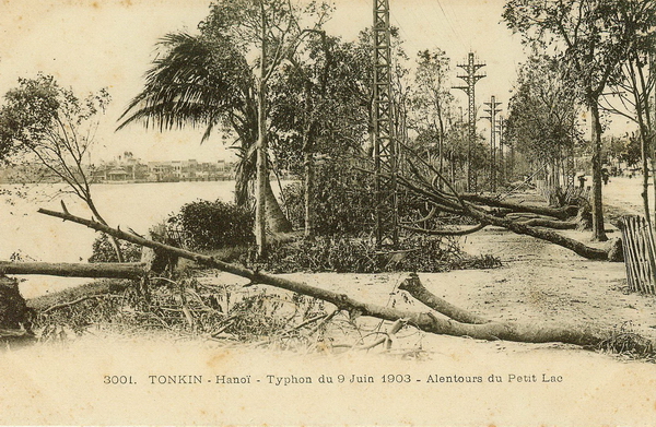
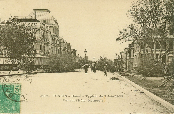
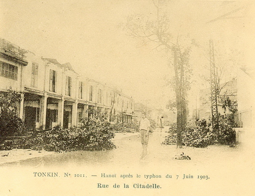
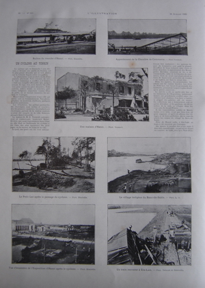
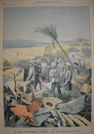
Cyclones are part of the life of Vietnamese people…
On the 7th June 1903, a violent cyclone hit the north / mainly the Provinces of Nam Dinh, Thai Binh, and reached Hanoi on this Sunday in the evening. Hundred of victims and huge damages to houses, public buildings and infrastructures..
Also to remember than in Hue, on the 11th September 1904, a cyclone caused the largest damage to the Province of Thua Thien: more than 700 victims, 25 000 houses destroyed…
SYDNEY — Weather-related catastrophes brought about by climate change are increasing, the top UN humanitarian official said Sunday as he warned of the possibility of “mega-disasters”.
John Holmes, the Under-Secretary General for Humanitarian Affairs, said one of the biggest challenges facing the aid community was the problems stemming from changing weather patterns.
“When it comes meteorological disasters, weather-related disasters, then there is a trend upwards connected with climate change,” Holmes, who is in Australia for high-level talks on humanitarian aid, told AFP.
“The trend is there is terms of floods, and cyclones, and droughts.”
Holmes, who is the UN’s emergency relief coordinator, said it had been a tough year due to January’s devastating earthquake in Haiti, which killed more than 250,000 people.
He said while earthquakes, such as the 7.0-magnitude quake which levelled the Haitian capital Port-au-Prince, were random, weather-related natural disasters were increasing in number and scale.
“It’s partly the very obvious things like the number of cyclones and the intensity of the cyclones, and the amount of flooding,” he said.
“But is also in slightly more invisible ways—in Africa with drought spreading, desertification spreading.”
Holmes said officials were particularly concerned about places where a combination of factors—such as large populations, or likelihood of earthquake, or susceptibility to rising sea levels—made them more vulnerable.
“One of things we worry about is mega cities could produce, at some point, a mega disaster,” he said.
“Cities like Kathmandu for example, which sits on two earthquake faults, where a large earthquake will come along… and the results could be catastrophic.”
JOHANNESBURG, 3 June 2010 (IRIN) - Climate change is not only testing the resilience of people, but also of development and disaster risk reduction projects set up to help people. Now, there may be a way to make the gamble more favourable.
If you were a small or medium-size NGO trying to set up a project in a flood-prone area in Bangladesh or Mozambique, you might not be aware of the climate risks. And if you knew that floods might wash away any structure you put up, what do you do?
Well, you build a structure with “two walls that will collapse on impact by a rapid flood, so the remainder of the house remains standing and occupants are not harmed, but in the knowledge that repairs will be necessary,” is the advice given by a new environmental tool.
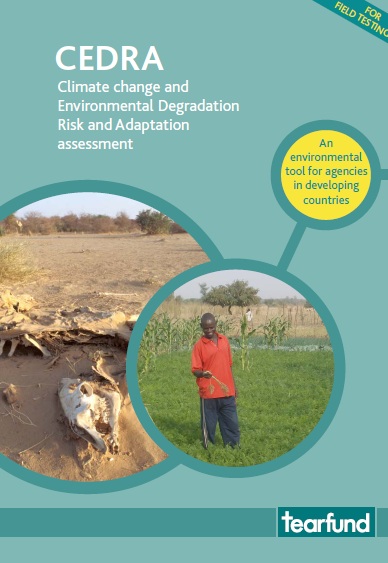
Tearfund, an international relief and development NGO with experience dating back to the 1990s, designed the tool to help small and medium-size NGOs assess the risks, manage them, and - where possible - adapt to them.
The tool, called Climate change and Environmental Degradation Risk and Adaptation assessment (CEDRA), helps NGOs access and understand climate change and environmental degradation, and the science behind it, and compare this with local experience of environmental change.
“There are lots of tools out there to help national governments or donors, but we assessed them and realized they did not really help the small NGOs working in developing countries,” said Sarah Wiggins of Tearfund.
The NGO developed the tool - which Wiggins described as a “framework” - by using their experience of problems as a result of changing weather patterns in countries like Afghanistan.
She presented the CEDRA at a side event at the latest round of climate change talks in Bonn, Germany, which examined “Practical solutions to tackle climate vulnerability – from climate information to capacity-building”.
The event
CEDRA involves six steps: identifying environmental hazards, prioritizing hazards that need to be addressed, selecting adaptation options, addressing unmanageable risks, considering new project locations, and a process of continual review, which should take place every year.
It provides a check-list for each of the steps, with samples of questions that need to be asked, and underlines the involvement of beneficiary communities at every stage.
“Ask open questions to gather information,” the CEDRA assessment advises. “Instead of asking ‘Is there less rain?’ ask ‘What is the weather situation like now? How has it changed over the last ten years? Or since you were a child?’”
Knowing the community, tapping their information, and understanding their needs can help make or break a project, as Tearfund discovered while trying to launch a radio project in Afghanistan in the 1990s to teach people how to adapt to climate change and environmental degradation.
A 70-year-old man opposed the project, saying, “Disasters are the will of God. Why are you trying to interfere with God’s will?” Tearfund’s local team responded by telling them “the story of Nu Allai Salam, from the Quran, who listened to the will of God and prepared for the coming disastrous flood and saved himself and his family and all the animals.”
This was acceptable to the old man, who was impressed by the team’s Quranic knowledge and how they wanted to use it in their project activities. “The radio project is now highly regarded in informing people how to adapt to the impacts of climate change and environmental degradation,” Wiggins said.
“Managing risk has been promoted through religious teachings throughout history,” she commented. The tool is being piloted in 10 countries and Tearfund hopes to roll it out in others countries in the next five years. “We are still learning and improving on it.”
See http://tilz.tearfund.org/Topics/Environmental+Sustainability/CEDRA.htm
MANILA, 3 June 2010 (IRIN) - Eight months after successive storms and typhoons brought misery and death to the Philippines, people evacuated from areas prone to flooding have returned to rebuild shoddy structures that could again put their lives in danger as the country prepares for this year’s storm season. Around Manila, destroyed shanties along spillways, tributaries and the country’s largest lake have re-emerged largely because people have nowhere else to go. This scenario could have fatal consequences in a country battered by an average of more than 20 storms a year during the rainy season from now to January, disaster risk and urban planners say. “Where do you expect the poor to go? We have no alternative but to rebuild and pray that the storms and floods will not be as bad this year,” said Teodosio Gacer, a community organizer at North Triangle, a 97ha slum with about 30,000 people north of Manila.
Living on the edge
About 35 percent of Manila’s 12 million people live in slums that are vulnerable to natural disasters and disease. Lying in the shadow of a huge shopping centre, North Triangle escaped heavy damage last year, although many families still sought temporary shelter. Other slums were wiped off the map in September when tropical storm Ketsana dumped the heaviest rains seen in more than 40 years and flooded about 80 percent of Manila.
A week later, typhoon Parma ravaged the northern part of Luzon Island, while a third typhoon, Mirinae, hit in early October. More than 1,000 people were killed and 10 million affected, according to government data. Many of those displaced have since returned to rebuild their homes in areas they were told to abandon, city and urban planners say. Ketsana “should have served as a lesson, but unfortunately, what we are seeing now is that there appears to be no realization of the dangers,” Robert Nacianceno, general manager of the Metro Manila Development Authority (MMDA), said at a recent public forum on government flood-control preparations. MMDA manages development in the Philippine capital and tries to ensure communities follow proper zoning and rubbish-disposal guidelines to avert the risk of flooding. “Part of the solution is to make sure that obstructions such as illegal houses and structures [along rivers and spillways] will be demolished,” said Nacianceno, adding that crews have been trying to relocate people who have returned to dangerous areas in Manila. Disaster waiting to happen Meanwhile, more than 50,000 shanty towns have been illegally rebuilt in low-lying lakeshore communities, apparently with the tacit approval of local government officials, authorities overseeing Laguna Lake warned.
At 900 sqkm, Laguna Lake, the largest inland body of water in the country, spans six provinces and 61 towns and cities, including 29 lakeshore communities and many poorly planned enclaves and residential areas.
Rains brought by Ketsana caused the lake to burst its banks, and with canals and drainage systems clogged, water flowed into Manila’s smaller rivers and waterways, causing flooding. At the height of the storm, the lake’s water level rose 14m to a 90-year high, authorities said. “Officials in local governments of lakeshore communities need to start looking into this problem to prevent a repeat of last year. This is simply a disaster waiting to happen,” said Edgar Manda, head of the Laguna Lake Development Authority. Explosive urban growth could undermine disaster planning, said experts at the forum. “Disaster risk has become, and will continue to be, an increasingly urban problem,” said Margareta Wahlström, UN Special Representative of the Secretary-General for Disaster Risk Reduction at the meeting. “The largest and costliest disasters from the last 12 months affected cities where risk is concentrated.” Figures released during the forum show that urban populations in developing countries have risen 77 percent in the last 10 years to nearly 2.6 billion, while the number of people living in urban slums surpassed 60 million during the same period.
According to Mr. Tran Van Sap, Deputy General Director of the National Centre of Meteorology and Hydrology (NCHMF), temperatures in the next coming months will be much higher than average and more intense, combined with a stronger humidity level.
In the last month, temperatures already reached record levels and will continue to be in the months June and July. There are three to four heat waves predicted and ten peak moments where temperatures can reach 10 to 41 degrees Celsius. The most affected areas are the Northern Central and Central regions.
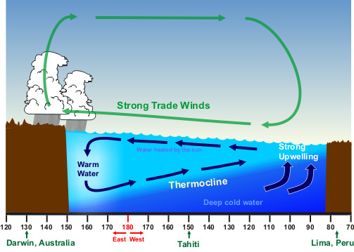
These weather extremes are linked to the effects of El Nino, starting from October 2009 and weakening in June 2010. After weakening, El Nino is likely to change into the La Nina phenomenon: during a period of La Niña, the sea surface temperature across the equatorial Eastern Central Pacific Ocean will be lower than normal by 3-5 degrees Celsius (see graph). Under the influence of La Nina, the frequency of storms may not increase, but the intensity of storms likely will.
This year, Vietnam will be affected by 6 to 7 tropical storms, equivalent in number to last year. However, the intensity of the storms will be higher; the storms will occur later in the year and will more likely target the south.
More detailed information on El Nino and El Nina can be found here.
The earthquake that wreaked havoc on Port-au-Prince, Haiti, earlier this year, and the continuing fallout of volcanic ash from Iceland that has paralysed large parts of Europe, reinforce the urgency for cities to take the necessary steps to put in place much-needed disaster reduction plans.
With more than half the world’s population living in urban areas, cities are particularly vulnerable to the risks of natural hazards, such as earthquakes, drought and floods. To strengthen a city’s readiness to reduce disaster impacts, the United Nations International Strategy for Disaster Reduction (UNISDR) is launching this Sunday, 30 May 2010 in Bonn, Germany, a new campaign to raise awareness and boost commitment for sustainable development practices that will increase a city’s well-being and safety.
The two-year campaign, Making Cities Resilient: My City is Getting Ready, urges leaders and local governments to commit to a checklist of Ten Essentials that will make their cities more resilient.
“A resilient city and its citizens can benefit greatly from the opportunities presented by urban risk reduction actions,” said Margareta Wahlström, UN Special Representative of the Secretary-General for Disaster Risk Reduction. “When successfully mobilized, resilient cities may benefit from growth and employment, business opportunities, balanced ecosystems, better health and improved education.”
The aim of the campaign is to enlist over 1,000 local government leaders worldwide to invest more in disaster risk reduction, which includes: improving urban planning, infrastructure and building safety; reinforcing drainage systems to reduce flood, storm and health threats; installing early warning systems; conducting public preparedness drills; and taking measures to adapt to the increasing impacts of climate change.
“Cities all over the world are looking for the best possible options for the future of their citizens and economies,” said Mayor Jürgen Nimptsch of Bonn, Germany. “The way to secure this future is through resilience. The more cities and citizens that are prepared, the greater the chances are for disaster reduction.”
Nimptsch, as well as leaders from five other cities – Mexico City, Mexico; Saint Louis, Senegal; Karlstad, Sweden; Larreynaga-Malpaisillo, Nicaragua; and Albay, the Philippines – will be the first to sign up and commit to one or more of the Ten Essentials at a campaign launch, which will take place during the First World Congress on Cities and Adaptation to Climate Change in Bonn from 28-30 May 2010.
“It is fundamental that we as local leaders are conscious about the risks,” said Enrique Gomez Toruño, the mayor of Larreynaga-Malpaisillo in Nicaragua. “We learned a lot during the recent influenza epidemics and before that from Hurricane Mitch, floods and landslides. We learned we have to invest more time, more capacities to reduce our risks.”
In addition to the commitment of government leaders, the campaign also calls on local community groups, planners, academia, NGOs and the private sector to join in the efforts to make as many cities as resilient as possible.
“Urban risk reduction is an opportunity that cities and their populations cannot afford to miss,” added Margareta Wahlström. “We are inviting people everywhere to take an active role in the campaign so that our cities and urban centres can become safer today and for generations to come.”
The UNISDR Secretariat is the overall coordinator of the 2010-2011 World Disaster Reduction Campaign. However, local, regional and international partners as well as participating cities and local governments are the main drivers of the initiative.
UN-HABITAT, with its broader World Urban Campaign, is a key partner, along with other UN agencies such as WHO and UNICEF, which are already working on hospital and school safety. UNISDR is also working with city associations and organizations, including the United Cities and Local Governments (UCLG), ICLEI-Local Governments for Sustainability and CityNet.
End notes:
The six leaders to sign up to the campaign in Bonn, Germany, on 30 May 2010 are:
• Jürgen Nimptsch, Mayor of Bonn, Germany
• Marcelo Ebrard, Mayor of Mexico City
• Cheikh Mamadou Abiboulaye Dieye, Mayor of Saint Louis, Senegal
• Enrique GomezToruño, Mayor of Larreynaga-Malpaisillo, Nicaragua
• Ake Pettersson Frykberg, Vice Mayor of Karlstad, Sweden
• Joey Sarte Salceda, Provincial Governor of Albay, the Philippines
There will be additional signing events on 31 May at the International Disaster and Risk Conference (IDRC) in Davos, Switzerland, and in Lima, Peru, at a meeting hosted by the Andean Community of Nations, as well as from 8-9 June in New Delhi, India, at a regional conference sponsored by India’s National Institute for Disaster Management, and from 28-31 July in Shanghai, China, at the Shanghai Expo 2010.
Additional information
http://www.unisdr.org/english/campaigns/campaign2010-2011/news/v.php?id=14030
Related Links
Making Cities Resilient: “My city is getting ready” campaign 2010-11 http://www.unisdr.org/english/campaigns/campaign2010-2011/

NAIROBI, 31 May 2010 (IRIN) - Bangladesh, Indonesia, Iran and Pakistan top a new ranking of countries at “extreme risk” of experiencing natural disasters compiled by a global risk assessment company.
The Natural Disaster Risk Index (NDRI), released on 27 May by Maplecroft, ranks 229 countries according to the human impact of natural disasters in terms of deaths per annum and per million of population, plus the frequency of events as well as the likelihood of earthquakes, volcanic eruptions, tsunamis, storms, flooding, droughts, landslides, extreme temperatures and epidemics. Asia accounts for most of the disaster-related deaths since 1980.
Ranking countries most vulnerable to natural disasters over the past 30 years could enable businesses and investors to identify risks to international assets while supporting humanitarian efforts to push governments into investing in disaster risk reduction initiatives.
African countries at extreme risk are Ethiopia, Sudan and Mozambique, with 95 percent of casualties due to drought. Since 1980 drought has caused 9,800 deaths in Ethiopia, 5,300 in Sudan (ranked fifth) and over 3,400 in Mozambique (ninth).
According to experts, unlike earthquakes and storms, drought damage is more difficult to detect, both in terms of human lives and economic loss because it is a slow onset disaster.
Whereas France and Italy, respectively ranked 17 and 18, are the most vulnerable countries in Europe because of the 40,000 people who died in heat waves in 2003 and 2006, the US, with more than 8,000 lives lost over 30 years, is highly susceptible to hurricanes and storms and ranked 37th.
Haiti and China are respectively at numbers eight and 12 among the countries at highest risk. The earthquake in Qinghai Province on 13 April 2010, of almost the same magnitude as the one that hit Haiti on 12 January, cost the lives of 2,187 people, against 230,000 who died in Haiti.
The countries least at risk are Andorra, Bahrain, Gibraltar, Liechtenstein, Malta, Monaco, Qatar, San Marino and the United Arab Emirates.
In line with the data produced by Maplecroft, a study by the UN Development Programme says that 85 percent of the people exposed to earthquakes, tropical cyclones, floods and droughts in the past 10 years live in countries having either medium or low human development.
Pedro Dabase, head of the UN International Strategy for Disaster Risk Reduction (ISDR) regional office for Africa, told IRIN: “In these types of rankings, the variables to look at are the time period of analysed data, types of hazards and vulnerabilities to natural disasters. This is because countries that face similar patterns of natural hazards often experience widely differing impacts when disasters occur, depending in large part on the kind of development choices they have made.
“If one looks at the frequency of earthquakes and cyclones in Haiti in the past 100 years, the situation of the country would not be considered as worrisome, unlike the past 10 years, with great human losses caused by flooding almost every year and hurricanes in 2004, 2005 and 2008.
“In terms of impacts for example, the recent earthquake in Chile, of the same magnitude as Haiti, recorded about 100,000 deaths but in terms of economic losses it registered US$22 billion, versus the $8 billion estimated for Haiti. Therefore, the vulnerability of Chile in terms of economic loss is higher than Haiti, which instead caused more losses in terms of human lives,” Dabase told IRIN.
Figures produced by the Centre for Research on the Epidemiology of Disasters (CRED) at the beginning of 2010 highlighted that in the past 10 years 3,852 disasters killed more than 780,000 people, affecting more than two billion and causing an economic loss of $960 billion.
According to ISDR, earthquakes, followed by storms (22 percent) and extreme temperatures (11 percent) are the deadliest natural hazards of the past 10 years and remain a serious threat to millions of people worldwide.
ISDR also ranked the Indian Ocean tsunami of 2004 as the most deadly disaster of the decade, with 226,408 deaths; followed by Cyclone Nargis in Myanmar in 2008, which killed 138,366 people, and the Sichuan earthquake in China in 2008, causing the deaths of 87,476 people.
“Due to climate change, extreme hydro-meteorological events are predicted to increase and given the impact on the countries not at risk of being directly affected by natural disaster, we advise the need for even the wealthiest countries to focus on disaster risk reduction,” said Maplecroft’s environmental analyst, Anna Moss.
See http://www.maplecroft.com/about/news/natural_disasters.html
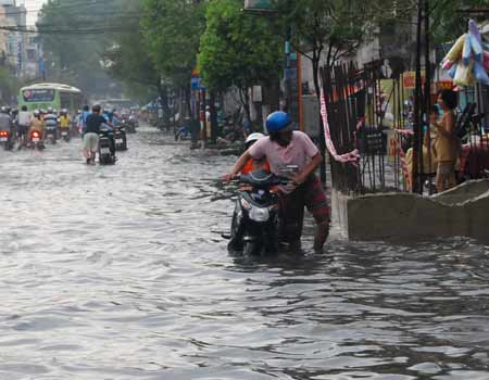
VietNamNet Bridge – Instead of developing the city to the East-Northeastern direction, with its higher topography, HCM City chose the opposite direction. Many new residential areas have been built in southern Nha Be area, where there were reservoirs in the past. As a result, flooding in Saigon is getting more serious.
This is the opinion of many construction experts, which they presented at a May 25 meeting to seek solutions to prevent flooding in HCM City.
HCM City is located downstream of the Dong Nai-Saigon river system, so it is nicknamed “city flooded by tides”. Low areas accounts for up to 61 percent of the city, which has nearly 7900km of canals. The major way for discharging flood water is North-Northwest-Northeast and South-Southeast-Southwest directions.
“The more modern urban areas expand in South Saigon, Binh Chanh, Nha Be and District 7, the more the city’s water discharging channel is hindered,” noted Prof. Le Huy Ba.
Phu My Hung new residential area is located in a low-lying area that hosted natural lakes in the past. Meanwhile, Nha Be and District 7 – the major sewage channel – are being powerfully urbanized, resulting in the disappearance of many canals.
HCM City has nearly 700 rivers and canals but 47 of them, totaling more than 16 hectares, were filled from 1990 to 2004. Districts 8 and 6 are heavily flooded owing to urbanization in South Saigon area.
Some pointed to HCM City’s mistakes in construction. “In 1954-1975, experts proposed the city to develop toward high-lying areas in the East-Northeast direction and not to the South – Nha Be – Can Gio because this area is sunken and has a weak foundation,” observed Bach Anh Tuan from Ton Duc Thang University.
“Why does the city develop new residential areas in the lower regions?” questioned former director of the Institute for Hydrometeorology, Pham Van Hoach.
Many analysts maintained that the factors causing floods in HCM City are made by humans, such as fast urbanization and ineffective construction plans. Consequently, flooding is more serious. The city now has 163 flooded places in its 24 districts.
Experts advised that, besides ongoing flood prevention projects, the city needs to take more urgent measures. “The city should ban filling up canals and build reservoirs to contain the volume of water that is not discharged immediately after downpours,” suggested Ba.
They also proposed to restrict construction of high-rise building in the southeastern area. Tuan suggested having green areas in residential areas where rain water can absorb into the ground.
“If the city doesn’t make immediate changes, we will have to sit here to discuss measures against flooding in the future,” Hoach concluded.
Some ongoing flood prevention projects in HCM City:
1. Comprehensive plan on water drainage for HCM City to 2020, which was approved by the Government in 2001 to upgrade and build the city’s drainage system and repair the current canals and reservoirs to improve the drainage capacity of canal systems.
2. Nhieu Loc-Thi Nghe environmental hygiene project to dredge and expand the Nhieu Loc-Thi Nghe canal, build the canal embankment and treat water before it runs to the canal.
3. Project to upgrade the residential area along Tan Hoa-Lo Gom canal to deal with pollution in this canal.
4. Project to improve the environment of Tau Hu-Ben Nghe-Kenh Doi-Kenh Te and Hang Bang canals to improve the drainage system in this area.
Deputy PM Hoàng Trung Hải ordered the Ministry of Natural Resources and Environment to take prime responsibility of developing and finalizing the Strategies and Action Plans against impacts of the global climate change for Ministries, sectors and some provinces.
The action plans should incorporate projects and programs relating to climate change to make it easy for future capital allocation and mobilization, the Deputy PM said. Ministries, sectors and localities need to review climate change projects and divide them into domestically-funded, foreign funded, short-term, or long-term categories.
He urged relevant bodies to issue criteria for a climate change project, create related administrative forms and appoint implementers who will work with donors for maximum financial resources in the time to come.
Recently, Việt Nam has received increasing technical and financial support and assistance from the international community in addressing impacts of the global climate change. The total support given to Việt Nam has amounted to US $1 billion so far.
ADB, NDF fund Viet Nam’s climate change efforts
With financial support from the Nordic Development Fund (NDF), the Asian Development Bank plans to grant technical support worth USD2.5 million to Viet Nam’s National Target Programme to Respond to Climate Change, and Da Nang City is one of the localities benefiting from the project.
In two years, the project will help enhance the capacity of Da Nang authorities to develop and take measures to reduce green house gas emissions, seek alterantive energy sources, and minimise risks due to climate change.
State President Nguyen Minh Triet has sent a letter to people throughout the country on the Traditional Day for Natural Disaster Control and Mitigation, May 22 in Vietnam.
“Over the past few years, natural disasters have hit most continents around the world, causing huge losses of human life and property for many nations. Storms and earthquakes with a terrible destructive power have claimed the lives of hundreds of thousands people and destroyed tens thousands of houses.
Vietnam is one of the countries suffering the strongest impacts of natural disasters and climate change. Flash floods, tidal surges and powerful storms have occurred more frequently, causing greater losses and badly affecting the country’s socio-economic life.
In the first quarter of this year, our country has faced abnormal weather with widespread hot spells which have reduced water levels in rivers and streams to very low levels, negatively affecting people’s lives and production, particularly agriculture.
Natural disasters will continue to become more complex with unforeseeable developments. All sectors and all people across the country should be vigilant and active and brace themselves for every possible bad weather situation in order to successfully implement targets for socio-economic development in 2010 and the following years.”
To mark the 64th anniversary of the Traditional Day for Natural Disaster Control and Mitigation, President Nguyen Minh Triet urges all people and local committees tasked with flood and storm prevention and control to work hand in hand to tackle the issue in 2010.
The French Development Agency (AFD) will provide a 20-million-Euro loan to Vietnam to contribute to the Support Program to respond to climate change (SP-RCC), the organisation announced on May 14.
This budgetary support comes in addition to the 10-billion-Yen loan (around 85 millions Euros) that has been granted by the Government of Japan to support this initiative.
In case the sea-level would rise of one meter, close to 5% of Vietnam’s land, 11% of its population, 7% of its agricultural land would be affected. Vietnam’s GDP would suffer from a 10% negative impact.
Confronted to these challenges, the Vietnamese Prime Minister has approved the National Target Program to Respond to Climate Change (NTP-RCC) in December 2008. Japan International Cooperation Agency (JICA) and AFD will support NTP-RCC implementation through their commitment to finance SP-RCC.
This programme aims at promoting the development of a legal and regulatory framework to foster climate change mitigation and adaptation measures as well as at facilitating the implementation of pilot actions. It will allow for GHG emissions reduction and capacity strengthening for the State to better respond to climate change impacts.